

The Beartooth Highway – RV Heaven

The Beartooth Highway is one of the more spectacular drives you can take when touring in your RV out West, comparable to the Going-to-the-Sun Road in Glacier National Park. It’s a 1930s WPA project that opened access to the Yellowstone region from the northeast, and an impressive engineering accomplishment.
Fortunately for us, it’s still in good repair and easily traversable by all but the most anemic RVs – there are probably a few gas Class As that shouldn’t attempt it, but the rest of us can drive it easily.
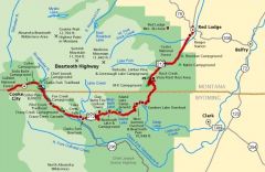
The eastern end of the Beartooth Highway is Red Lodge, MT, a 44 mile drive from I-90 coming down US 212 from Laurel, just west of Billings. Red Lodge is a nice little town with all the RV amenities – water and a dump station at the Chamber of Commerce, groceries at the IGA, gas, diesel and propane from multiple stations. Provision yourself well because the next significant amenities are when you come back out on I-90 in Livingston, MT, 175 miles away.
OK, now that you’re all stocked up, get ready to climb. We’re going up onto the Beartooth Plateau, a 10,000-foot-high tableland overlooking the Yellowstone caldera. Trouble is, you’re at 5500 feet in Red Lodge. After a gently sloping approach up the valley, the switchbacks begin. Most of it is 25 or 30 miles an hour – feel free to take it slower. Turn off your air conditioner, and watch your coolant temperature and transmission temperature gauges. Five miles of switchbacks later, you’re rewarded with a view of the plateau.
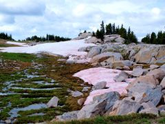
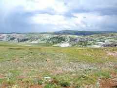
First thing you’ll notice is the snow. There’s snow up here – side-of-the-road snow, not up-on-the-mountains snow. I came up here in late June, and it’s all over the place. Even in August, there’s still snow you can easily walk to from the highway. The snowmelt feeds countless streams; most of the time you stop along the highway you can hear running water. The northern sides of the gentle hills on the plateau have snowbanks, each with a stream emerging from its base.
The second thing you’ll notice is the thin, cold air. Atmospheric pressure is 70% of sea level, and it’s 20 degrees cooler up here in the summer than it is down in the Yellowstone River valley. Daytime highs are rarely above 70 degrees. Pace yourself if you plan any hikes, and watch out for signs of altitude sickness if you zoomed up here without acclimating.
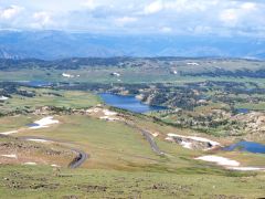
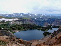
The first few miles of the plateau drive leading up to Beartooth Pass are still in Montana; I boondocked in a spur (Forest Service Road 2124) just before the state line, which is designated for dispersed camping. As you cross into Wyoming, you’re climbing – you’ll be rewarded with spectacular views of Gardner Lake and Mirror Lake.
In addition to the main lakes, the complex landforms up here create smaller lakes seemingly cantilevered out of the steep slopes. Every dip in the terrain up here holds water.
bearstooth
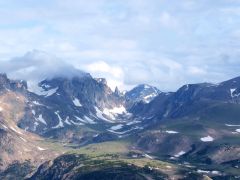
The Bear’s Tooth is a spire of granite viewable from the highway just before the pass. Native Americans named this range because of this feature, which does indeed look like an incisor of something you wouldn’t want to meet on the trail. The tooth and many of the other peaks are “horns” – glacially carved spires sharpened to impossibly steep points as glaciers slid around their sides during the numerous ice ages which shaped this region.
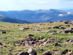
At the top, Beartooth Pass itself has a pullout to stretch your legs and look around in all directions. East you can see the Bighorns, over 80 miles away, and south of you is a plateau covered with lakes. Fiona the Fearless Kitty had less esthetic interests – she wanted to snag a marmot. Marmots are chubby rodents who inhabit alpine regions and, as Fiona was soon to discover, always sit within feet of their burrow. No marmot on the menu for Fiona this time.
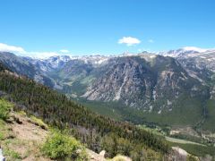
West of the pass, the road descends steadily and you come down off the tundra and back into pine forests. Spectacular waterfalls dot the roadside, many with pullouts and paths leading up to them so you can get a closer look. The state line also marks the boundary between the Custer National Forest and Shoshone National Forest, which you are in now, and there are several well-maintained campgrounds along this stretch of the highway.
Island Lake, Beartooth Lake, Crazy Creek, and Fox Creek range in elevation from 9,000 to 6,000 feet. Information on these is available on the Shoshone National Forest website. Fox Creek has electricity, for those of you not equipped for dry camping.
Somewhat averse to organized camping and neighbors ourselves, right now we’re doing dispersed camping maybe eight miles east of the town of Cooke City, on the Clark’s Fork of the Yellowstone River. Just pull off the road, pick a spot, and enjoy the wilderness. The sound of rushing water, the smell of the pine trees, and the song of the mountain bluebirds make this place a memorable stay in our exploration of the Beartooth area.
0 Comments
Recommended Comments
There are no comments to display.
Please sign in to comment
You will be able to leave a comment after signing in
Sign In Now