On to Mount Isa
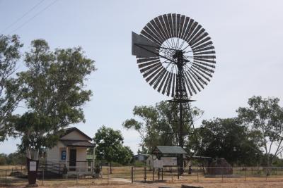
 After experiencing a rash of road repair work on our drive the day before we were pleasantly surprised to encounter no road work on our second day of driving. In fact, with just a few exceptions, this was some of the best road we have traveled. This highway is known as the Flinders Highway and is the only all-weather east-west road through northern Queensland. There were only a few towns in the 652 kilometer drive. One of them is featured in the picture with this posting. The windmill was working, drawing water for the public restrooms in the picture. The road was nearly flat all the way and had few curves. I could set the cruise control and concentrate on staying between the lines. An added plus is that the drivers out here wave at you. Even the native Australians wave at a rental campervan! We would encounter a vehicle every five or ten minutes and were passed by a vehicle only a few times an hour. It was a long trip on a lonely road.
The truck trains which are posted as being up to 53.5 meters (about 160 feet) long are not driving much faster than we are. We met one or two of them several times an hour but we never had to pass one and were never passed by one so I assume our speed nearly matched their speed. We were driving about 97 KPH which was well under the posted speed limit of 130 KPH (about 85 MPH). The campervan will cruise at 110 KPH without difficulty but it severely reduces our mileage on a liter of fuel. It also makes the ride a little rougher, this vehicle rocks and rolls enough already. Fuel mileage is an important concern because the communities are widely scattered and the distance between fuel stops isn’t posted on any signs. In the US you see signs posted indicating how far to the next fuel stop on stretches of road that have widely separated stations. Here you are on your own. The map we have indicates all the small communities but not all of them have fuel so we have to plan on only the larger communities having fuel. I keep the tank topped off so we have a minimum of ½ tank if possible. We made two stops on this trip, both after about 250 kilometers of travel. Fuel prices are running close to $2.00 per liter at this point.
Just before reaching Mount Isa the road goes through some hills. The road curves and climbs and descends and our travel is slowed for the last 30 kilometers as we come into town. Mount Isa (pronounced Iza) is a mining town and has the look of a mining town. There are active mines here and smelters with tall stacks spewing smoke. We could see the smoke for some distance before we reached the town itself. The smoke was white in the late afternoon sun and may have been simply water vapor or mostly water vapor.
We stayed at the Discovery Argylla Big 4 Park which was right on the Flinders Highway as we came into town.
We parked, hooked up electric and settled in for the evening. Temperatures during the day had been in the upper 30’s, near 100 degrees F. We are running the air conditioning at night now, at least long enough to cool the campervan so we can open the windows and ventilate during the night. By morning it is nice and cool inside and we are glad to see the morning sun.


0 Comments
Recommended Comments
There are no comments to display.
Please sign in to comment
You will be able to leave a comment after signing in
Sign In Now