
We Finally Find Cool in the Pacific Northwest

Leaving the midwest in late June we battled temperatures near or above 100 degrees on a regular basis. Even as we traveled to Montana we were still enountering temperatures in the high 90s. When we got into eastern Washington we began to notice some cooler temperatures. Now, after crossing the Cascade Mountains we have arrived at Chehalis, Washington. We are about 90 miles south of Seattle on I-5. Temperatures here are in the 50's and 60's at night and highs have been in the upper 70's or lower 80's. We've had some rain and plenty of clouds. This is more like what we expected when we decided to travel in this direction.
Our ultimate goal is the Olympic Peninsula and Olympic National Park. The weather will be even cooler, cloudier, and wetter than it is here. We'll see how long we can stand the cool weather! We are having some repair work done at Cummins Northwest here in Chehalis. The parts should all be waiting for us now and we have an appointment on Monday morning. If all goes well, we should be on our way to the Olympic Peninsula by Monday afternoon.
We have had a great time in central Washington. This was our second visit to the Grand Coulee area and we learn more each time. The tour at Grand Coulee Dam has changed as they are now remodeling the powerhouse which used to be the tour area. This time we toured the pumping facility for filling Banks Lake which serves as the reservoir for irrigating this part of the state. Banks Lake fills the Grand Coulee from near Grand Coulee Dam on to Coulee City where a small dam across the coulee blocks its flow. The town of Coulee City has a wonderful community park there with a beach on the lake. The RV sites have full hookups with 30A for some and 50A for others. The pull through sites are not real level but we managed to find a spot where we could level the coach. We fell in love with the town. Everyone was friendly and helpful including the people at city hall where we had a package shipped.
Just below Coulee City is one of the truly amazing features of the area, Dry Falls is a waterfall that was active for only 48 hours as the glacial lake, Lake Missoula, emptied when its ice dam failed. Lake Missoula was larger than any of the Great Lakes today and was as much as 2000 feet deep. Imagine pulling the plug on that and the ensuing havoc that occurred. The Grand Coulee and other coulees in the area were formed by this sudden flush of water over the land. Dry Falls is 3 1/2 miles long and 900 feet tall. When the water was flowing over the falls it would have been 300 feet deep and reached speeds of 60+ miles per hour. This ripping force tore away the columnar lava flows in the area easily forming these great gashes, called coulees, in the landscape.
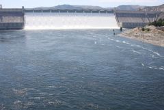
It is a wet year in the northwest and all the dams in the area show this. The spillways are running at or near capacity to keep the level of the lakes from becoming higher than dam design. This makes for a very dramatic scene and the sound is nothing but pure power. Of course the Corps of Engineers sees this as a tremendous loss of resouces, energy and irrigation that will be needed someday. On our tour of Grand Coulee Dam where we got a ride across the dam in a bus and a stop to look over the dam to the spillway with its flowing water. Several days later we toured the Chief Joseph Dam, about 30 miles from Coulee City at the town of Bridgeport. This turned out to be a hidden gem. We pulled up to the security gate and called the security office. It indicated tours were available so we asked for a tour. We were checked through security, ID's, car inspection, under the hood, opening doors and hatch, and finally using a mirror to check under the car. Then we were given our visitors badge and directed to park in an area where the tour guide would meet us.
After a wait of about 10 minutes our tour guide arrived. She loaded us into a golf cart, just Louise and I, no one else. Hard hats were brought along, this was going to be good. We drove past the power house with its 28 generators all in a row, right up to the base of the dam. Unlock the door and we were inside the base of the dam. An elevator took us to the top where we were able to look over the side of the dam above and get the layout of the flow of the Columbia River up to the dam. This dam is a "flow of the river" dam, designed to allow all the rivers flow through the dam. As a result there is only a small lake above the dam. Even with 28 generators, there was still water going over the spillway here. We walked down several flights of stairs to the trunion bridge. This is a walkway along the front of the dam at the level of the trunions or bearings on which the flood gates pivot up and down. Just below and in front of us we were looking at the water spewing from below the gates which were all lifted except for four and an additional one under repair. The roaring water on the spillway was below our feet about 20 feet.
We made a pass through the visitors center which has exhibits that are only seen on tour now. In the good old days before September 11, 2001 people could drive across the dam, park on top of the structure and then walk into the visitors center and take a tour. Now the tours are on-demand and no one staffs the visitors center. We viewed a short film on construction of the dam and its operation then put on our hard hats. We were escorted into the power house to walk along the top of the generators. One was being rebuilt, new bearings, new turbine, etc. This gave us a chance to see the equipment disassembled. There was the monsterous rotor, sitting on the floor. Its massive magnets visible as were the windings of the stator past which the magnets spin to generate the 60 cycle current we all desire. Our guide points out an assembly on the floor next to the rotor and gives a Jeopardy clue then asks what those blocks look like. She mentioned automobile work and I correctly identified the brake pads which are used to stop the generator when it is shut down. Easy, they were 2 feet by 3 feet and looked about 4 inches thick. An arrangment of eight were spaced around a huge brake shoe which had a hole for the shaft, they had to be brake pads!
We stand atop one of the operating generators and feel the vibrations in our feet. Then it is down a long flight of stairs to the operating floor. We walk past several generators in operation to go down a short stairway and walk right up to the spinning shaft that connects the turbine to the generator above. We are encouraged to reach out a hand a touch the shaft. For a science teacher, this is a cool as it gets! Then we go down two more flights of stairs and now we are looking a the top of the turbine assembly. This one is operating and water is flowing through the turbine just below us. We can see the actuators which move the gates that direct the water into the turbine. On our way our of the power plant we pass two small generators which provide the electrical power to operate the power plant and dam itself. I laughed and pointed out to Louise the cover of the "in-service" light atop one of the generators was off and there in all its glory was a twisty flourescent light bulb. Here we are in the middle of a facility that is generating more than 2000 megawatts and they are using a flourescent light bulb to save electricity. We were touring the dam for almost two hours. It was without a doubt the best dam tour we have ever had. The only downside was that cameras were prohibited so we have no pictures of all this great stuff.
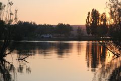
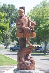
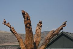
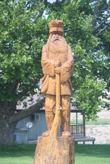
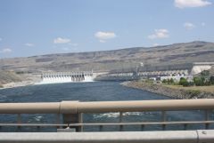
Back to the car and into Bridgeport for lunch. Surprise, this little town is larger than we expected. We are welcomed into town by a series of creative sentinals. Trees that once lined the street had died and their stumps were carved into figures of people, animals and other art forms. Wow, another unexpected find. There was an advertisement for Nel's Cafe and Bait Shop so we had to eat there! We enjoyed a nice lunch then drove around town to see what else this town offered. We found a nice RV park right along the Columbia River. As we exited the town we drove across the bridge over the Columbia River which gave us our best views of the Chief Joseph Dam. Louise snapped pictures as I drove across the bridge. Then it was back to Coulee City for a BBQ and rest watching the sun set over Banks Lake.
1 Comment
Recommended Comments
Please sign in to comment
You will be able to leave a comment after signing in
Sign In Now