GrampaDennis
-
Content Count
107 -
Joined
-
Last visited
-
Days Won
1
Everything posted by GrampaDennis
-
From the album: Maine Foliage Trip
-
From the album: Maine Foliage Trip
-
From the album: Maine Foliage Trip
-
From the album: Maine Foliage Trip
-
From the album: Maine Foliage Trip
-
From the album: Maine Foliage Trip
-
From the album: Maine Foliage Trip
-
From the album: Maine Foliage Trip
-
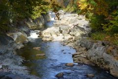
From the album: Maine Foliage Trip
-
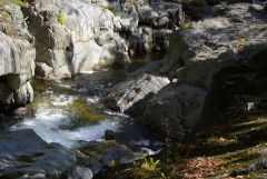
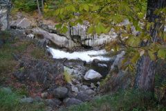
From the album: Maine Foliage Trip
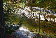
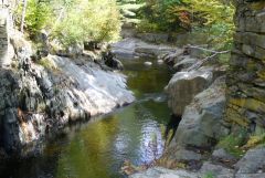
There are several nice little waterfalls here. -
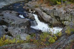
From the album: Maine Foliage Trip
-
From the album: Maine Foliage Trip
-
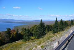
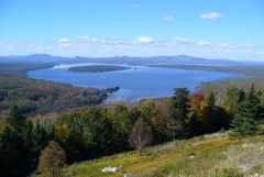
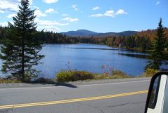
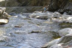
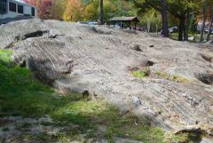
On September 28th and 29th, Grandma and I took a weekend trip to some very scenic places not far from our home. After watching our grandson's Saturday morning soccer game, we headed up Route 17, which passes through our town, and continued to its end in Oquossoc. From there, we took Route 16, through Rangeley, to Stratton. From Stratton, we headed north up Route 27 to Eustis, where we stayed overnight at Cathedral Pines CG. On Sunday, we followed Route 27 south through Bigelow and Carabasset to Farmington. From Farmington, we followed Routes 2 & 27 east to New Sharon, then south on Route 27 to Belgrade Lakes, then Route 135 to our home in Readfield. The foliage was almost at its peak in most of the places we went. I am attaching an album of a few of the photos I took. I'll add a few words here about the places we stopped along the way. We were pleasantly surprised to find gas advertised at $3.439 at a Cumberland Farms store in Livermore Falls. I have one of their SmartPay discount cards (10 cents off), so I topped off the tank. Coos Canyon, on the Swift River in Byron, was a great stop. We pulled into a rest area and had a super view of the little canyon from our table in the MH while we had lunch. After some sightseeing, on a short and easy hike, we explored the store and rock shop across the street. They have all kinds of rocks, minerals, gems and jewelry there and the prices seem reasonable. There's a small amount of gold in the Swift River and this place caters to rock hounds and amateur prospectors. You can buy or rent your gold panning equipment here. By appointment, you can get lessons as well. They also sell books on the subject. They had several jewelry items made with actual Swift River gold nuggets in epoxy or tiny display cases. Some of these were priced under $100. One of my photos shows a guy panning in the river. There is also a campground here. One of these days, I may go back and try my hand at panning! Route 17 climbs up a ridge called "Height of Land" We stopped at the Height of Land scenic turnout, which offers a fantastic view to the north and west. Mooselookmeguntic lake is the big one in the foreground. Some of the mountains you see from here are in New Hampshire. A few more miles up the road, another scenic turnout looks north and east, over Rangeley Lake. This was a very nice view as well. We didn't actually stop in Rangeley, though there are some interesting restaurants, shops and museums there. Between Rangeley and Stratton, we went up Quill Hill. I wouldn't do that again with a Class A motorhome, even though the view was tremendous, I'll do another post with more detail on Quill Hill. Cathedral Pines Campground is on the North Branch of the Dead River, which flows into Flagstaff Lake. This CG is in a large grove of tall red pine. All sites are shaded much of the time, which would be an advantage in hot weather. The campsites are very generous in size and spaced out well. Many of them would be big enough to take 2 or 3 RV's, if you were traveling in a group. They have very few sewered sites, but have 3 dump stations. Our site had water and 30 amp electric. The campground is very neat and well-maintained. I have heard from friends that they have a special area for larger groups, across Route 27 from the main CG. There is a general store within sight of the campground entrance. We went there first. This store is quite well stocked with food items and other necessities. There is no store in the campground itself. We didn't stop much on our way home on Sunday, though we passed the entrance to Sugarloaf Ski Area and went through New Portland, where the historic Wire Bridge is located. Though we didn't stop at the Wire Bridge this time (been there before), it's definitely a stop I would recommend. It is one of the very earliest suspension bridges in the country, and it is in a very pretty setting on the Carrabassett River. We stopped for lunch at an old truss bridge on the Sandy River, off Route 2 in New Sharon. This bridge is barricaded off, but the old section of road was a convenient place to park the MH while we had our meal. We got home early enough on Sunday that I had time before dark to wash the Quill Hill dirt off the MH. We are fortunate to live in an area where such a nice trip is doable in less than a full weekend!
-
On the way to PEI, we had taken a northerly route from Moncton, via Rotue 15 by Shediac. To see something different, we decided to take the southern route by Sackville. Grandma was navigating and she suggested we take Route 106 through Dieppe and Moncton, thinking it would save some distance, compared to TransCanada Route 2 around the north side of Moncton. It may have saved us distance, but I don't believe it saved any time, as it led right through the heart of the city. As we were coming to the west side of the central part of Moncton, we were suddenly confronted by a low overpass. I stopped and decided there was no way I would risk going under the thing. Fortunately, there was a left turn available from where I stopped. I took that and we felt our way along until we got back on Route 106. Grandma and I decided that she had not done a much better job of navigating than Bess (the GPS) had on PEI. I had been searching our big, fat, Woodalls campground directory for a place to stay between Moncton and Saint John. We found a place called "Three Bears." When we got there, at 6:30 PM, the store and office was closed, but the gate was open. There was a nice couple sitting out on the deck of their seasonal site near the store. I talked with them and they suggested I just come in and pick a site. They would call the owners for me. I picked a full hookup site and got set up, but the owners didn't return the call. The nice folks said the owners were usually there by 9 AM, so I said I would just settle with them in the morning. We had a nice walk around the campground in the evening. We could tell by the shape of the main building that it had once been a KOA. This place was heavily settled by seasonal campers. There were a lot more sites than what appeared from the entrance area. We didn't hurry about getting up in the morning. When I was unhooked and ready to go, it was 9:30 AM on Friday morning. The owners had still not showed up and the door to the store was locked. The neighbors that greeted us in the evening were not up and around, either. I wrote a note, including my address, and put $40 with it. We drove out the gate and started to look for a place to leave the note and money. At that point, we saw someone in the store. Grandma got out and approached the service window. The person in the store first said that he didn't work there, and couldn't help us. He said he was just peeling carrots and potatoes for a community dinner later that day. Grandma convinced him to take our note and the money to give to the proprietors. It was a reasonably nice campground, but a strange way to run a business. Back in 2001, I had attended a conference in Saint John. In fact, I was there during the 9-11 attacks. One of the things that impressed me about Saint John was their indoor Marketplace Mall and City Market. These are built in a series of old and new buildings, connected by enclosed walkways over the streets. It looks like a great place to shop in the winter! I wanted to show this place to Grandma, so we found our way to the area and eventually found some on-street metered parking big enough to accomodate our Cottage on Wheels. We had a nice tour of the shopping area and ate in a seafood restaurant that looked out onto Kings Square. We also looked at the olympic swimming pool and training center that is attached by another ovehead walkway. Saint John is nice. I recommend a stop there. We had a little rain and fog, but not much wind as we completed the trip across New Brunswick via the southern coastal route, TransCanada 1. We skipped making any scenic stops, due to the weather and our desire to get back into Maine for the night. We crossed th border from Saint Stephen to Calais. We expected that we might be searched, at least somewhat, but we weren't. The US Customs agent did ask to come in to the coach, but once in, he just handed back our passports and wished us a nice day. We drove back along the Airline Road, Route 9. Along the way,our windshield wipers quit during a rainstorm. I stopped and managed to get them going again, though the wiper park function wouldn't work. Grandma said "don't touch them as long as they are working." (I later discovered that the problem was a loose connector on the electronic module that controls various wiper functions.) There are no campgrounds listed in the Woodall's directory for that route until you get almost to Bangor. However, there are 2 or 3 small places that are not listed in the directory. We stopped at a semi-rundown store/motel/restaurant/campground in Beddington. It turns out that this is a favorite place of the ATV crowd. Most of the campers there were using it as a base for their ATV trips. All of the sites with working hookups were taken, but they let us dry-camp in a nice corner of the place for $10 plus tax. There was another couple in a motor home doing the same thing. The next morning, Saturday, we drove to Bangor and did a little shopping at the big mall there. We arrived home in the early afternoon.
-
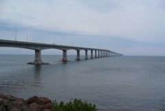
During the week after Labor Day, we took a trip to Prince Edward Island, Canada. It was the longest trip with our "Cottage on Wheels" so far. As I'm typing the story, it's getting a bit long, so I am breaking it into two parts. The attached album includes a few of the many photos I took. We left home on a Friday evening, after I got done work. We stopped at a Wal-Mart in Newport where we hosted a visit by friends. As they left, our friends pointed out a slack tire. I had just checked the pressures the night before! I found that I had a loose valve stem extension. We got air from one of those wimpy coin operated compressors at a gas station nearby. It cost me 3 or 4 bucks to fill the tire! Instead of continuing on to Bangor, as originally planned, we decided to stay overnight at that Wal-Mart and recheck the tire in the morning. On Saturday morning, the tire pressure was still up. Tightening the valve stem extension did the trick. (Side note - I have since bought an air compressor to carry in the MH with us. Now, we have air readily available.) We went a bit out of our way, to Mars Hill, Maine, where we had a nice visit with friends that we have not seen for a while. After an overnight there, we crossed the border at Houlton, ME and traveled across New Brunswick to Prince Edward Island. It was mostly good road, with many long hills. There were a few scenic spots, but much of the journey across NB was wooded, without much else for scenery. This is like driving to Northern Maine, but more so. When we got to the Confederation Bridge, the visibility was not great. It was foggy, with occasional light rain. We could only see about 3 spans ahead of us. We were headed for Twin Shores Campground in Darnley, which is in the northwest corner of the central section of the island. We decided to let "Bess" (our GPS) guide us to Twin Shores. Bess did OK for a while. She led us along lightly traveled secondary roads through beautiful farming country and small villages. As we were abut 2/3 of the way across the island, Bess told me to turn left, off the numbered route we were on. I followed the instruction, but found that this road was almost all patches and a bit rough. Just as I was hoping for it to get better, it got worse. Up ahead was a long, steep hill with no pavement, just a couple of wheel tracks in the red clay. To complicate matters, it started raining harder. As we reached the end of the pavement, I was looking for a good place to turn around. I passed about 3 driveways that were steep downhill from the road before I found one that was nearly level. That one had wood rail fences on each side, but I managed to back in without hitting anything. We got out of there, but found out later that we had picked up a good coating of that famous PEI red dirt! After that little GPS mis-adventure, we ignored Bess and navigated by the map for the rest of the way to Twin Shores. I've had cases where the GPS wanted to take me on a direct route over a bad road before, but none as inconvenient as this was. Maybe one of those new, more expensive, RV specific GPS units would be worth the price. They claim that they analyze the routes and only put you on roads that are suitable for your RV. Twin Shores was huge! They have around 800 campsites. We stayed in an older section where there were spruce or fir trees planted as hedges between the sites. Each site was a semi-private nook, well separated from the neighbors. The store, laundromat and other facilities were nice, though not everything was operating this late in the season. There was a lot of acreage involved. The newer sections were more open, but with great views of Darnley Basin, grass-covered dunes and a large open field. We did a lot of walking, and just plain relaxing at Twin Shores. On Wednesday morning, we set out toward the eastern shore of the island. We stopped at several scenic turnouts, parks, and a couple of pottery and craft shops along the way. At the entrance to one of the parks, there were a couple of foxes by the road near the entrance. They were not bashful about traffic. In fact, they appeared to be begging for food. We didn't feed them. Generally, we agree with the philosophy that feeding wild animals does them more harm than good. We had heard of a beach with "singing sands" that make a tinkling sound or something when blown by the wind. It's near the northeast corner of the island. We didn't get that far. While we were stopped at Basin Head, there were dark clouds coming and we decided to look for a place to camp. We had recently passed Red Point Provincial Park, which had "Camping" listed on its sign, so we turned back there. Red Point was a gem! Being late in the season, the park was far from crowded. I picked a site high in a field, where we had that corner of the park to ourselves and a panoramic ocean view. The only thing missing was the surf sound which we would have heard if we picked a site close to the water. Wednesday evening, the weather forecast warned that the remnants of a tropical storm was coming on Friday, with heavy rains and high winds. We did not want to be crossing the Confederation Bridge in our motor home in high winds. Therefore, we decided to cut our tour of PEI a bit short and get back into New Brunswick on Thursday. Thursday morning, we drove directly to Charlottetown. There, we got off the main highway and wended our way to some metered parking alongside a park near the downtown area. I fed two meters with enough coin for a couple of hours, then we walked into the central part of town and to the waterfront. We ate at a second floor restaurant with a nice view of the harbor, but the food was not that great. We treated ourselves to "Cows" ice cream, which is supposed to be PEI's premium brand. Mine was OK, but I've had better. From Charlottetown, we drove to, and across, the Confederation Bridge. The wind had not come up yet. The visibility was better than out first crossing, but still somewhat limited. I'll finish the trip in Part 2.
-
A selection of photos from our September 2013 trip to Prince Edward Island
-
-
From the album: GrampaDennis PEI Trip
-
From the album: GrampaDennis PEI Trip
This is the bridge to Prince Edward Island, from the New Brunswick side. Visibility wasn't great that day. With the naked eye, we could barely make out the far shore. The bridge is about 8 miles long. -
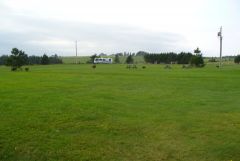
From the album: GrampaDennis PEI Trip
Not too crowded! -
From the album: GrampaDennis PEI Trip
© That's us in the corner
-
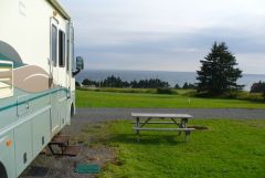
From the album: GrampaDennis PEI Trip
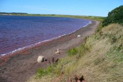
This was a Provincial Park. Being late in the season, we chose a high spot with a nice view and had that corner of the park all to ourselves! -
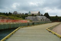
From the album: GrampaDennis PEI Trip
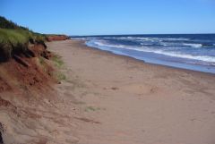
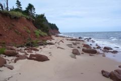
There is a museum, restored fish cannery, gift shop, etc., at this park, which is also on a nice beach. -
From the album: GrampaDennis PEI Trip
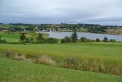
A very picturesque village on the French River, which outlets on the North Shore of PEI. -
From the album: GrampaDennis PEI Trip
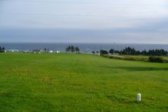
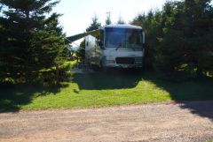
The older campsites had hedges of fir trees around them. Each site had its own little nook, which was well separated from the neighbors. Nice! -

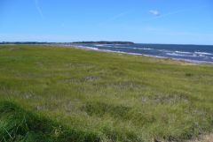
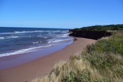
Atlantic Shore looking east from edge of field at Twin Shores CG
GrampaDennis posted a gallery image in Members Gallery
From the album: GrampaDennis PEI Trip