

Roadtrekingmike
-
Content Count
669 -
Joined
-
Last visited
-
Days Won
17
Everything posted by Roadtrekingmike
-
Jennifer has one requirement as we travel: We find a place to work out. She’s a fitness instructor by occupation, though lately, because of our near-fulltime traveling schedule, she’s had to cut back on the classes she teaches. But that doesn’t mean she cuts back on her fitness goals. We're on a very hectic Great Lakes Shoreline Tour that we’re doing for Verizon Wireles, so finding time to pull over and find a gym hasn’t happened as much as she’d like. I can usually tell when I better get her to a gym because she starts to get a bit cranky. So, in answer to a reader’s question about where Jennifer finds places to work out, we put together this How We Roll in our RV video. Jennifer talks about the Silver Sneakers fitness program. Joining it gets you in at more than 11,000 locations, as we found with the Anytime Fitness chain we chose. Many health insurance plans also include Slver Sneaker benefits. Meantime, some of the national fitness places you can look into include: Snap Fitness Planet Fitness Fitness 19 LA Fitness Curves (women only) Workout Anytime The video above was shot at the Anytime Fitness gym in Saulte Ste Marie, Mich.
-
The Great Lakes Shoreline Tour: Lake Huron’s Upper Peninsula Coast
Roadtrekingmike posted a blog entry in Roadtreking Blog
Oh, boy. There goes the schedule. With 10 segments due on our Verizon Wireless Tour of the Great Lakes shoreline across eight states, I have a pretty ambitious travel schedule. We were doing all right until we crossed over the Big Mac Bridge into Michigan’s Upper Peninsula following the Lake Huron shoreline. But then we were seduced by the wide open spaces, the sparkling blue water, the big freighters and clean, fresh lake air. Instead of sticking to the schedule, we tossed the planning aside and ended up staying over for a few extra and unscheduled days. Oh. One other thing. My estimate that the tour would cover about 3,500 miles when it was all done is way short of what it will actually be. It looks like our meanderings and following sometimes obscure shoreline roads will make this trip closer to 4,500 miles when we finish. But right now, who cares? This is one of the best trips we’ve ever taken in our Roadtrek Etrek and following a timetable with so many delightful surprises around every shoreline bend seems, well, almost sacrilegious. There’s a different feel to the Lake Huron shoreline as soon as you cross over the UP. It is quieter, more protected and it calls the visitor to sit and stay a little longer, just gazing out at its island-studded waters. Just check out this video above you’ll see what I mean. Those islands you see as soon as you start to round the shoreline in the Eastern Upper Peninsula on state highway 134 past St. Ignace are known as Les Cheneaux Islands. They consist of three dozen small islands located just offshore, islands perfect for fishing, and exploring, especially by kayak, where quiet coves and sheltered bays beckon the adventurer. They stretch through the waterfront communities of Hessel and Cedarville, almost to the far eastern end of the lake where it is fed by the St. Mary’s River in Detour Village. Jesse Hadley runs a small shop in Hessel that specializes in eco-tours of Les Cheneaux Islands. She’s passionate about sharing it…but also protecting it. “A lot of people don’t know about these islands,” she said. “Most of the people who live around here have families who have been here for generations. We’re all a little protective of them. They are so unique and beautiful and the water and sky are unlike no place else in the Great Lakes region.” In Detour Village, we stopped by the small museum in Detour, dedicated to the area’s rich history as the northern starting point of the big lake. And then we followed the river northwest to Saulte Ste. Marie, We camped right on the broad river bank, at the Soo Locks Campground. We planned on just a night. But we became so mesmerized at watching the huge lake freighters go by that we spent three nights. “It’s so relaxing up here,” said Linda Grant, of Lexington, KY, who with husband, Bill, has been coming to the Soo Locks Campground each summer for more than three decades. “Down in Kentucky it’s 92. Up here it’s very nice with the cool breeze off the water.” The Locks are where Lake Superior meets Lake Huron. It was there we said goodbye to Huron, whose Michigan shoreline had us travel more than 500 miles from Port Huron and get ready for our next Lake – Superior. Look for the first part of that trip in our next report from the Great Lakes Shoreline Tour. Meantime, if you’d like to follow the tour and keep up with our route, check out the embedded map on the right hand column of this page. If you click on the map it will open full screen. Then you can click the waypoints and see a photo and where we are and what we’re seeing. Jennifer and me and Tai watching freighters from our spot at the Soo Locks Campground in Saulte Ste Marie, Mich. Les Cheneaux Islands along Lake Huron’s northern shore in the Upper Peninsula of Michigan Those big freighters go by day and night. -
RV Destination: Michigan’s Buggy Bois Blanc Island
Roadtrekingmike posted a blog entry in Roadtreking Blog
Scratch another place off my bucket list: Bois Blanc Island, in the middle of Michigan’s Straits of Mackinac, half way between the Upper Peninsula and the Lower. As we were rounding the Lake Huron shoreline of the Michigan Mitt and driving through the northeastern town of Cheboygan on our Verizon Great Lakes Shoreline Tour, we saw a sign that directed us to the ferry dock. The Straits of Mackinac were right off our righthand side as we made our way north on US 23 but this ferry was not for Mackinac Island – Michigan’s most popular tourist destination – but for Bois Blanc Island, called by the locals “Bob lo.” It was calling to me big time. Now it was time to visit. After all, unlike Mackinac Island, motor vehicles are allowed on Bois Blanc. That meant it had shoreline to drive. So we made a spur of the moment decision: Let’s Go! We loaded our Roadtrek Etrek motorhome on the ferry operated by Plaunt Transportation. Round trip for two adults and the Roadtrek was about $96, cash only. Forty-five minutes later, we pulled off into a different world. With a fulltime population of about 60 and measuring roughly 12 miles long and six miles wide, the island has no paved roads, no traffic signals and few stop signs. Deer outnumber permanent residents by about 20 to one. We saw deeralmost everywhere we looked. People, not so much. That was just fine for us. Cottages and summer homes help push the summertime population to a couple of thousand. But during our visit, the only time we saw other people was when we passed the bar or visited Hawks Landing, the combination general store-restaurant- gas station and real estate office that serves as the island’s nerve center. It was at Hawks that we found a place to camp, owned by one of the locals and a few miles down the shoreline. They even had a 30 amp power hookup and water to boot. Truthfully, we probably could have stayed anywhere. There were numerous spots to pull off, right on the coast. On the northern end of the island there was another spot, without hookups, that we could have stayed for free. But it was surrounded by cedars and the mosquitos and tiny, biting black flies were congregated there out of the wind. We decided to go for the paid spot on the south side. Even there, we had mosquitoes trying to get inside. Check this video: Think they don’t do damage? Check this video. I shot this the next day when we returned to the mainland and I got a hotel room to get some relief from the insects. Truthfully, as beautiful as Bois Blanc was, the bugs in late June were so bad that we wished we hadn’t come. Later in the summer when they die down or, better yet in the fall when a killing frost puts them away for good, would be a better time to visit. There’s some disagreement over the name. Bois Blanc means “white wood” in French. The color of the prevalent birch tree bark and the basswood tree’s white under bark that was extensively used by Native Americans and the French-speaking fur traders who first came to the island to make canoes. Why, then, do the locals call it “Bob Lo?” They have as long as anyone can remember. The term is believed to be an English corruption of the French pronunciation of the name. The Great Lakes has several other islands called Bois Blanc, including one in the Detroit River that used to be the location of a popular amusement park. All those other Bois Blancs are also called Bob Lo by the locals. At any rate, except for the bugs, we found the place to be delightfully low-keyed and out of the way place. What it lacked in amenities, it more than made up for in tranquility, beauty and a jaw-dropping display of stars in a sky totally devoid of light pollution. If only the bugs had left us alone A roundtrip to Bois Blanc Island cost $96 for two adults and the Roadtrek. Tai loved being free on the deserted beaches. This is one camping spot on the north side. It’s a great boondocking place but the mosquitoes were so bad we moved to the south shore. They were bad there, too, just not as bad. -
Using Apps to Track and Share Your RV Travel
Roadtrekingmike posted a blog entry in Roadtreking Blog
Summer travel and vacation is upon us and as many of us hit the road, we’re sharing our travel with friends and families. Many of you know I also am a techology correspondent for the 215 NBC-TV Newschannel affiliate stations across the country. I do a weekly “PC MIke” Tech feature for the network and, these days, I am usually doing it from the back of my Roadtrek Etrek as we travel the country. In this week’s report, I featured three apps and Internet services that can map and track your travel routes. In this digital age, instead of postcards, more and more of us are posting real-time maps, photos, video and travel reports. The video above is from this week’s PC Mike segment. It features three ways apps and the Internet can help you share your traveling adventures. For iPhone and iPad users, check out the free Track My Tour app and website. You start a route and through the app, add updates as you travel. It grabs your GPS location from your device and displays it, and your comments and the photos you take on an interactive map. I’m doing one right now as I tour of the Great Lakes region. The app is free, though there is an upgraded version that lets you have some extra features. If you want to follow along, .. Click here to TrackMyTour! Meanwhile, here are sme other similar tech tools you may want to try for your RV travels. Check My Tour is a similar app, geared towards cyclists and motorcycle trips, though it will also work with regular roadtrips. It is for Apple devices but also Android smartphones. Then there’s My Trip Journal. This allows you to set up your own travel blog website. It maps your routes and lets you write reports and updates and allows you to have a travel journal that can be viewed by whoever you share it with. By the way, I also am a big user of Twitter as we travel. I live tweet from the road as we travel. If you use Twitter, you can follow me @roadtreking or send me a tweet with the hashtag #roadtreking. -
Michigan’s Sunrise Side is one of the best-kept secrets in the Great Lakes. The state’s west coast Lake Michigan PR machine has done a better job of promoting the beaches and trendy little communities there while the Lake Huron coast along the state’s east coast has stayed purposefully low-keyed. And that has been just fine with the locals and the sharp-eyed tourists who love the area. That means there are no traffic jams. Prices for food, lodging and the like are usually more affordable than the tourist-dense Michigan west coast. And for RVers, that means more places to camp with more space, better views and less competition for the best spots. But the reason we like the Sunrise Side so much is because of the sunrises. Check out the pictures below. Some sunrises are an explosion of pastels. Others bright gold and yellow. Every one is worth getting up for. We’re now over 1,500 miles into our Verizon Wireless Great Lakes Shoreline Tour of the U.S.-side of the Great Lakes. And this leg, called the Sunrise Side, follows us from the start of Lake Huron in Port Huron, MI to the very tip of the Lower Peninsula Mitt in Mackinaw City, MI In so doing, we found what just may be the prettiest two coastal roads in the region. Granted, there may be shorter roads elsewhere that are more spectacular. But mile for mile, you just can’t beat US-25 from Port Huron to Bay City, and US-23, from Bay City to Mackinaw City. Most people take the I-75 interstate up the middle of the state. But the shoreline roads are much more fun and relaxing. Both hug the Huron shoreline and offer numerous pull outs, roadside, county and state parks with lake views, stairs down to the wild shoreline and, often, camping. On our trip we stayed in two places, electing to do the drive in three days. Our first overnight was at the East Tawas State Park, located on the Tawas Bay Point. The Tawas Point is one of the best bird-watching spots in North America, smack dab on a migratory pathway. People from all over the world come here in late spring to birdwatch. Many of the birds had moved on during our visit, though I was able to see a nesting pair of piping plovers, an endangered species. You can see them in the video. We also overnighted in Alpena, MI, staying at the privately-owned Campers Cove RV Park located on the Thunder Bay River. The campground offers kayak rentals and shoreline fishing . The video shows why we stayed in Alpena, to take advantage of the Thunder Bay National Marine Sanctuary off the coast of Alpena, , an underwater preserve because of all the shipwrecks there. The three days we allotted for this seemed a bit rushed. If I was doing it over – and I will when we’re not on deadline or heading elsewhere – I ‘d make it at least five days. I’d add a stop just north of Port Huron at the Lakeport State Park and another just north of Rogers City at the P.H. Hoeft State Park Both are right on Lake Huron. And both offer great sunrises. If getting up early isn’t for you, we’ll talk about the sunsets when we hit Lakes Superior and Michigan later in the tour. Lake Huron sunrise Sunrise at Tawas The Tawas Point Lighthouse The Lake Huron shoreline along M-25
-
Lots of people have asked how I’m filing my Great Lakes Shoreline Tour reports and what tech gear I have on our Roadtrek Etrek. It was raining yesterday and we were stuck in cam so I did a short little video to show some of the gear I'm using. I’ll do more and show the drone and some other gadgets and gizmos in future reports, but right now, here’s what was handy as I was shooting the report. The Wilson Sleek cell phone booster I use comes with a small magnetic mount antenna, a couple of inches long. I replaced it with a longer one I found on Amazon that I have up on the roof of our Roadtrek Etrek. See the picture below. By the way, all the gear you see here – with the exception of the MiFi card – is my own, purchased by me at full retail. Verizon, which is sponsoring the Great Lakes Shoreline tour and compensates me for reports that appear on their corporate blog, provided the Mifi card and covers my data fees. Good thing, too, because last month in Canada, I forgot to turn roaming data off and racked up $3,000 in wireless fees during a two-week stay. But that’s another story and a mistake I won’t make again. I replaced the Wilson Sleek cell phone antenna with a longer one, on the roof of the motorhome.
-
The Great Lakes Shoreline Tour: Lakes Ontario and Erie
Roadtrekingmike posted a blog entry in Roadtreking Blog
I always knew I was lucky to live in Michigan, the very heart of the Great Lakes. But until I started this drive along the shoreline of all five Great Lakes, I didn’t realize how fortunate I truly am to call this area home. I also didn’t realize how interconnected they are. From a hydrological standpoint, they are all intermingled and pretty much part of one system. The water that passes the rocky northern Superior shore in Minnesota eventually makes its way to the sandy bluffs of Lake Ontario in upstate New York. And until I started out in our Roadtrek Etrek motorhome moving west from near Cape Vincent, NY, I was unaware of the amazing diversity of the land, the history, culture, economic import, beauty and recreational opportunities that make the Great Lakes the largest system of fresh, surface water on Earth, containing 84% of the U.S. fresh water supply and 21% of the entire planet’s supply. Our first leg took us from the eastern end of Lake Ontario in New York, on to Lake Erie in Pennsylvania and Ohio, north into Michigan and the start of the lake on the shores of the Lake Erie Metro Park, at the mouth of the Detroit River. Total distance was 702 miles. We were plagued by cloudy skies and intermittent rain most of the way. I used my 4g LTE Verizon connection – something we had pretty much the whole route – to scout for nearby attractions. Our first discovery was in Le Roy, NY, a half-hour from our campsite at the Lakeview State Park on the shores of Lake Ontario. Why Le Roy? Because that is where we found the Jell-O Museum and Gallery, an absolutely fascinating place that chronicles and celebrates America’s most famous desert. In 1897, Pearle Wait, a carpenter in Le Roy, experimented and came up with a fruit flavored dessert which his wife, May, named Jell-O. He tried to market his product but he lacked the capital and the experience. In 1899 he sold his formula for the sum of $450. The Jell-O Museum and Galley documents how the Jell-O’s success is a tribute to marketing and advertising. In 1904, a three-inch ad costing $336 in the Ladies Home Journal launched the printed portion of the campaign, and the first of the Jell-O “best seller” recipes rolled off the presses. In some years, as many as 15 million booklets were distributed. Noted artists such as Rose O’Neill, Maxfield Parrish, Coles Phillips, Norman Rockwell, Linn Ball, and Angus MacDonald made Jell-O a household word with their colored illustrations. Salesmen, well-trained, well groomed, well versed in the art of selling went out in “spanking rigs, drawn by beautiful horses” into the roads, byroads, fairs, country gatherings, church socials, and parties to advertise their product. First came team-drawn wagons, to be followed by smart auto-cars. Pictures, posters, and billboards over the American landscape, as well as magazine, carried the Jell-O Girl and the then six delicious flavors into the American home. Eventually, Jell-O was bought by General Foods and moved away from Le Roy. But the museum, staffed by local folk, is a delightful place of Americana nostalgia. We moved from Lake Ontario to Lake Erie. In Erie, PA, we spend a drizzly afternoon touring the 11-mile long, 3,200-acre sandy Presque Isle State Park, located on a peninsula that arches into Lake Erie. Besides numerous beaches, picnic areas and bike trails, the park boasts the Perry Monument, a 101 foot structure located at the eastern end of Presque Isle dedicated to Commodore Oliver Hazard Perry, who defeated the British fleet in the War of 1912. Standing next to Misery Bay – so named by the men of Perry’s naval squadron, who wintered here 1813-1814 after the crucial Battle of Lake Erie in September 1813 – the monument reminds us that if Perry hadn’t won, much of the Midwest would now likely be Canada. Further east into Ohio we overnighted on the shoreline at the Geneva State Park. In town, we visited the original old-fashioned soda fountain at the local drugstore where I had an early morning root beer float, the perfect way to start the day. We were headed back west when Jennifer did an Internet search (that 4g LTE Verizon network and our Mi-Fi card in the Roadtrek is better than a travel guide) where we discovered that the area has over 17 covered bridges and more than a dozen local wineries. The glaciated soil along the Grand River was laid there as the Great Lakes were being formed and is perfect for great grape production. At the Harpersfield Vineyard and Winery, we chatted up the winemaker himself and learned that the estate grown Pinot Noir and Chardonnay wines there are among the finest in North America. Then it was on to Vermilion, Ohio, where we attended the town’s annual Festival of the Fish, a weekend event boat parades, races, pageants, contests, food, entertainment, markets. We wanted to stick around for the fireworks but stiff winds blowing off the lake had postponed them for a day. While there, we met Christopher Gillcrist, executive director of the newly opened Great Lakes Historical Society Museum in Toledo. Gillcrest is a wealth of information about the Great Lakes and it’s importance. From there, it was back west and then, at the state border, up along the coast into Michigan, where the entire stretch of the lake from the Detroit River mouth south to Monroe and Toledo is one of the probably the most prolific walleye fisheries on the continent. Alas, the stiff winds following the storm front kept most boats in harbor during our visit. Standing on the shore, watching the Detroit River empty into the lake it formed so many eons ago, we realized all that water in front of us originated from the upper lakes. After a quick weekend home for Father’s Day, we looked forward to the next week 00when we would resume the shoreline tour – at the end of Lake Huron in Port Huron. Be sure and send along your tips on what we should see. You can Tweet me using the #VZGreatlakes, #Roadtreking and #PureMichigan hashtags. The native American’s who first lived on the shores of Lake Ontario in what is now upstate New York called it “the land of the shining water.” The Jello Museum and Gallery in Le Roy, N.Y. Our Lake Erie shoreline campsite at Geneva State Park in Ohio -
Thinking of a Type B RV? Here Are the Questions You Should Ask
Roadtrekingmike posted a blog entry in Roadtreking Blog
Buying an RV is perhaps the second biggest purchase most of us will make next to our house. In some cases, with kids grown and newly retired from our jobs, it becomes our house as more and more people embrace the fulltiming style of a life on wheels. And these days, Type B RVs seem to be at the top of the motorhome popularity chart. Many who bought larger Type A or C motorhomes are downsizing, or “rightsizing,,” as some call it, for the more mobile and maneuverable Type B-style campervan motorhome. For one thing, new retirees are coming into the marketplace every day. And today’s retirees are generally healthier and more active than those who came before. The first baby boomers turned 65 three years ago. According to a Social Security agency report, over the next two decades, nearly 80 million Americans will become eligible for Social Security benefits, more than 10,000 per day. So, in considering a Type B, what questions should be asked? To find out, we crowd sourced the question, asking current Type B owners, members of our very active Roadtreking Facebook Group. They are the true experts, whose collective wisdom is more reliable and real world than any of the pie in the sky promises you;ll get from commission hungry RV salemen. Here, then, is the advice of current Type B owners. Feel free to use comments below to add yours. And then pass this post along to a friend who may be considering a B. I’ve slightly edited some of the more than 50 comments we received to weed out duplicate content or to add clarity. I’ve also edited out specific references to a particular make or model so the information is as unbiased as possible. +++++++++++++++++++++++++++ Karsten Askeland: One of my biggest disappointments was RV dealer service after the sale. Buyers need to do their research on the dealer and ask for references and/or recommendations. Linda Joesting Collins: Mercedes, Chevy model? Advantages and disadvantages. Karin Bless: I see a big distinction also in the personalities of RVers. I find it important to just go into many different units, look around and imagine yourself spending your time in there and with whom, too. Only after this the more technical questions can be answered, because the selection has narrowed down then. Nancy Kay: Dealer service quality and proximity are so important. One other question to ask yourself before purchase if you are not fulltiming is where are you going to park it? How big can it be to fit there? What about weathering in the snow and sunlight. Do you have HOA restrictions? Darlene Meier: First thing I look for is size of bed (#1) and storage (#2). It is especial important if you plan to spend several weeks or months living in a B. Do you plan to eat your meals in the B, eat out, or a combination of the two? We do the combination, so the size of the fridge is not as important to us. Lisa Gruner: Gas vs diesel. When we were looking, my husband was glad to see diesel, ceilings tall enough for him, the twin bed layout with the electric sofa in the back, and the bathroom. Those were his hot buttons. We walked through several You have to decide on your list of wants and must haves and be ready to compromise on some of it. Partly because down the road you’ll figure out some mods to fix it up and you’ll be glad you made your decision. Deborah Skinner: We were coming out of an Airstream trailer and rightsizing into a B. The primary issues for us were something where I could share the driving as I pretty much refused to drive when towing the trailer – a comfortable and spacious bed – and a usable galley with decent refrigerator space. My husband wanted the Mercedes diesel for mileage and safety features – so those were the only models we considered. We are also not yet retired – but within a few years we plan to spend quite a bit of time roaming and we wanted a nimble footprint for that. Stephanie Alexander: Match the floor plan and size of RV to your needs and of course pick reputation of manufacturer Eric Sondeen: Fuel econ, layout, ease-of-use, riding positions (strap into all seats and ride), fit/finish, Drive & Park & Back, John Spears: Talk to present class B owners and ask what they like about their class B. Then the most important question is, “what DON’T they like about it”? If you don’t know a class B owner, go to the nearest RV park or campground and look around. Most would be very happy to talk about their RV experiences. Determine how it’s going to be used to determine which model to consider. Gas or diesel considerations have pretty well been taken care of in the comments above. Diesel fuel is not hard to find, as most gas stations and convenience stores have diesel pumps these days. Read all the blog posts you can find from present owners. Those posts are a wealth of information, but remember a few of them may need to be taken with a grain of salt. If you ever read product reviews on the net, there always seems to be at least one really bad review when all the rest are really good. William Browne: How are you going to use the RV? Stay in one place for periods of time or on the road and its a place to sleep and eat. Do you really need a lot of storage or not. Laura Loschky Robinson: How easy to operate? (ex. awning, bed, swivel chairs, oven, dumping, hooking and unhooking at sites) How easy to drive and handling? (length for parking, towing, maneuvering, mountains, rain, snow) How complicated and costly is maintenance? Diesel vs. gas. Headroom, storage. Is it comfortable for sleeping, driving, bathing, sitting eating? Is it roomy for 2 (width and length) Kids? Pets? How do you clean it inside and out? Cost? New vs. used. Resale value, Mileage, Longevity? Is van good for full time, part time, weekends? Can you boondock- ex. solar, generators, satellite, boosters, etc.. Is dealer timely (in and out quickly for maintenance) professional, fair, near me? Is there a maintenance program? Leesa Mundell: One of the most important factors, in addition to everything already mentioned, is comfort/ease in driving. We are “goers” who rarely spend more than one night in the same place, thus we are on the road a lot. We both love driving our motorhome, and feel safe in all kinds of conditions and weather. We can drive and park it anywhere, and some of our ventures have put us into places that a much longer/taller/wider rig could not have gone. All the other options for us were personal preference. Do your research and then go drive your top choices on busy streets and the highway, lie in the bed (and if regularly traveling with another person-both of you lie down together…some bed sizes are not as comfortable or convenient for two as they appear) sit inside the restroom, explore all the functions and storage areas. Make the right match for your lifestyle and you will have years of enjoyment! Husband Jeff adds, the only question to ask is, “What is the rig that makes my wife happy?” Burton Hill: For us, it was the “what are you gonna do with it?” question that was #1. We travel to National Parks. We tour. We don’t spend days/weeks in one spot. “Small House, BIG Backyard!” sums it up for us perfectly. Bob Clark: In short – you need to figure out FIRST how you want to live your mobile life. Our thought process was … A’s are out – too big, too expensive and too limiting. C’s were out because they were poor on gas, IMHO ugly, and many hung out way too far in the back. Didn’t want a trailer because then you had a base camp to set up and return to and (in most cases) you need an expensive pickup to lug it and I’d never own a pickup anyway. That left a turtle! Everything on board, pick up and go wherever/whenever, reasonable mileage, easy (or NO) setup/teardown, minimalist. That seemed to fit OUR intended lifestyle perfectly. Decide today where to go tomorrow, spend a LOT of time in the parks, if we like where we are, we may stay several days or weeks, if not, move on. Michele Alexander: Ask yourself: Do I want to merely travel across this great country or do I want to experience it? I have noticed that the travelers in smaller RVs seem to spend more time outdoors. What appealed to us when we chose the Class B was its versatility: Go anywhere a car can go (ditto parking) No need to tow another vehicle Not just for travel – we use it for all kinds of outdoor activities and events in our home area – so handy to have a refrigerator and bathroom with you! +++++++++++++++++++++++++++ So there you go. Here’s a final tip from me: Visit a large RV show that has many different RVs on display. Go in and out of each one. Find out what differentiates each model from the others. -
“Not all those who wander are lost." -- J. R. R. Tolkien in The Lord of the Rings. We love that quote because we love to meander, to take roads less traveled, off the Interstate. And as we are starting our Great Lakes Shoreline Tour that will take us 3,500 miles across eight states along the shorelines of all five Great Lakes, we are reminded again about the absolute joy of slow exploration. We’ve tried to explain it to non-RV people. Their eyes sort of glaze over. But you understand, don’t you? When we first began our motorhome adventure two years ago, I was so focused on arriving at our destination that I missed the adventure and thrill of getting there. I drove mega-mileage, 400, 500, even 600 miles a day. I’d arrive exhausted, cranky and wanting nothing but sleep. I guess that’s part of the newbie’s RVing education, learning to slow down. Now, it’s hard to get us out of an area. Even as I write this, in the tiny town of Geneva, Ohio, the heart of Ohio’s wine country, we have found so many things to see. Ohio? Wine? You better believe it. Parts of this area look like the Napa Valley in California. Really. It’s raining again. It has rained for the last four days. But no problem. There are wineries to tour, small town attractions. Winding roads. The local drug store has a long, old-fashioned soda fountain bar. I’m going to go see if I can get a cherry phosphate. We’ve traveled the U.S. shoreline of Lake Ontario and are now following Lake Erie. We’ll end this leg of the tour at the mouth of the Detroit River, the lake’s source, make our way home for the Father’s Day weekend and then pick it up again Tuesday with Lake Huron, starting in Port Huron, MI. Our first official report from the tour will be next week, sharing photos and videos here, as well as on the Verizon Wirelsss blog and the Pure Michigan blog. We’ll also tweet and post in Facebook and social media with #VZGreatLakes and #vzwmidwest. Let me know what you think we should see. We’ll probably avoid most of the big tourist attractions that everyone knows about. We want to highlight the surprises and little gems that delight and surprise. Let us know. Here’s one of those gems we discovered this week. This cow is out front of the Jell-O museum in Le Roy, N.Y. And, yes, there really is such a place. More later.
-
We’re about to set off on a 3,500-mile trip that will take us farther than if we drove across country, from the Atlantic to the Pacific. And although we till visit eight states, we will never really leave the Midwest. We’ll be driving much of the U.S. shorelines that touches the five Great Lakes. I’ve wanted to do this trip for years. ow, thanks to Verizon Wireless and in partnership with Pure Michigan, we’re about to set off, starting from the Lake Ontario shoreline near Otswego, NY, and then making our way to Lake Erie and Pennsylvania, Ohio and Michigan; continuing in Michigan along the shorelines of Lakes Huron, Superior and Michigan, and also visiting Wisconsin, Minnesota, Indiana and Illinois where Lake Michigan also shapes a vibrant coastline lifestyle. We’ll travel in our Roadtrek Erek motorhome, Jennifer and me and our Norwegian Elkhound, Tai, breaking the route into 10 different segments, and writing about the interesting people and places we encounter, sharing our reports, photos and videos here, as well as on the Verizon Wirelsss blog and the Pure Michigan blog. We’ll also tweet and post in Facebook and social media. The cool thing about this is, other than a general rote that will take us close to the Great lakes shorelines, we have no plans, no schedules, no firm appointments. This will be totally serendipity. We’ll stop whenever something catches our eye, talk to people, learn about the places we visit and try to document the amazing beauty, recreational opportunities, shoreline lifestyle and significance of the Great Lakes. Because of technology – that’s where Verizon comes in – I’ll be totally wired and connected the entire route, able to post pretty much from wherever we are, no matter how isolated or remote. If we were to drive the shoreline of the entire Great Lakes where they touch Canada and the U.S., it would be an amazingly long trip. We can’t, do that, of course, because some spots have no roads. But if we could, it would be a near 10,000 mile trip. The significance of the Great Lakes is staggering. According to the Great Lakes Information Network, an informational clearing house on the Great Lakes group supported by U.S. and Canadian governmental agencies and various civic-minded organizations,the five lakes contain: One-fifth of the world’s fresh surface water (only the polar ice caps and Lake Baikal in Siberia contain more); 95 percent of the U.S. supply; 84 percent of the surface water supply in North America. Spread evenly across the continental U.S., the Great Lakes would submerge the country under about 9.5 feet of water. More than 94,000 square miles/244,000 square kilometres of water (larger than the states of New York, New Jersey, Connecticut, Rhode Island, Massachusetts, Vermont, and New Hampshire combined, or about 23 percent of the province of Ontario). About 295,000 square miles/767,000 square kilometres in the watershed (the area where all the rivers and streams drain into the lakes). The Great Lakes shoreline is equal to almost 44 percent of the circumference of the earth, and Michigan’s Great Lakes coast totals 3,288 mi/5,294 km, more coastline than any state but Alaska. As we travel, we’ll camp in our Roadtrek, sometimes find hotels and B & B’s, sample local food, attend festivals, meet and profile the locals and soak as much in as possible. We plan to do all this in a month’s time. Got any ideas or suggestions? Use the contact form to send them in. And if you happen to see us out there, honk, wave or come say Hi. The adventure starts Thursday, June 12.
-
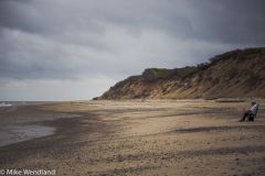
From the album: Cape Cod: Where all of America is behind you
We had the place to ourselves. Two weeks from now, in mid-June, it will be wall-to-wall humanity. -
Cape Cod: Where all of America is behind you
Roadtrekingmike added images to a gallery album in Members Gallery
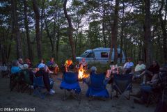
Attending the FMCA Roadtreking International Region 2 rally held at the Sweetwater Forest Campground in Brewster, MA. -
-
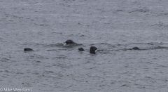
From the album: Cape Cod: Where all of America is behind you
Seals playing in the surf along the Cape Cod National Seashore -
From the album: Cape Cod: Where all of America is behind you
Our spot at the Sweetwater Forest Family Campground in Brewster, Mass. -
From the album: Cape Cod: Where all of America is behind you
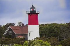
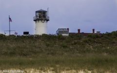
The Nauset Light. It’s on the logo for the famous Cape Cod Potato Chips sold nationwide. -
From the album: Cape Cod: Where all of America is behind you
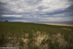
In early June, before school gets out for those in Boston and New York, the cape is all but deserted during the week. -
From the album: Cape Cod: Where all of America is behind you
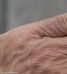
Watch out for ticks. The Cape is crawling with them. This is a particularly bad year. -
From the album: Cape Cod: Where all of America is behind you
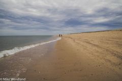
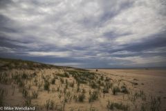
The Cape Cod National Seashore -
From the album: Cape Cod: Where all of America is behind you
The national seashore stretches 40 miles. -

From the album: Cape Cod: Where all of America is behind you
Cape Cod beach roses bloom all over the dunes on the beach. -
From the album: Cape Cod: Where all of America is behind you
One of the numerous lighthouses in the area -
From the album: Cape Cod: Where all of America is behind you
Part of the RTI group around the campfire -
Cape Cod: Where All of America is Behind You
Roadtrekingmike posted a blog entry in Roadtreking Blog
I confess to being a bit of a snob about the east. My journalist days often took me up and down the eastern seaboard, mostly to big cities where crime, decay, overcrowded neighborhoods and a general malaise of discontent seemed to be the chief characteristic of the people and places. Such is the danger of journalism. Seeing bad news makes you skeptical. Seeing too much bad news makes you a cynic. And being cynical is not a good way to live. So it’s good to visit the east now in an RV, where we have time to see the land and marvel at how wrong I was. It’s drop-dead gorgeous and, even on the turnpikes and interstates, the route we took to Cape Cod revealed wide open spaces, beautiful rolling hills and mountains and little towns and villages peppered with antique shops, the pleasant lines of New England architecture and history everywhere. We need to come back and spend more time. But our destination was the Cape and here we are, attending the FMCA Roadtreking International Region 2 rally held at the Sweetwater Forest Campground in Brewster, MA. There are over 100 Roadtrekers here for this event and getting to meet many for the first time has been a joy. The campground is huge, with private full hookup flat spots nested in trees amidst a hilly forest. We arrived Sunday afternoon. “I look so forward to just hanging around the camping spot, just sitting and relaxing,” I told Jennifer as we pulled in. She was silent for a second. “I don’t think so,” she finally replied. “After you drive me half way across the continent to a place surrounded by what are supposed to be the most beautiful beaches in the world, I don’t think ‘just sitting around’ is going to be on your agenda.” Okay then. So bright and early the next morning, we made our way to the Atlantic shore. The Cape Cod National Seashore was our destination, 40 miles of pristine sandy beach, marshes, ponds, and bicycle trails along the Atlantic-facing eastern shore of Cape Cod. We drove the whole seashore, stretching from Chatham to Provincetown, At numerous places we pulled off, and walked portions of the beach, touring an old Life Saving Station at the tip of Cape Cod, and taking in both National Parks Service Vistor Centers. There’s plenty out here for history buffs, too, with sites associated with the Pilgrims, Marconi’s first transatlantic wireless station and numerous lighthouses. Shipwreck lore abounds on the cape. So many ships have piled up on the hidden sand bars off the coast between Chatham and Provincetown that those 40 miles of sea have been called an “ocean graveyard.” Indeed, between Truro and Wellfleet alone, there have been more than 1,000 wrecks. In the early 1800s, there was an average of two wrecks every month during the winter. The loss of life seemed especially sad when a sailor managed to get ashore on a winter night only to freeze to death after he got there. In 1797, the Massachusetts Humane Society started putting up huts along the most dangerous sections of the Massachusetts coast in the hope that stranded sailors would find them and take shelter. It was not, however, until 1872, that a really efficient lifesaving service was put into operation by the United States government. Stations were erected every five miles on the beach. On November 11, 1620, the Pilgrims got their first look at the New World when they saw Cape Cod. In Provincetown, there’s a huge monument commemorating the Mayflower Pilgrims’ first landing in the New World in Provincetown. Here the Pilgrims spent five weeks exploring the tip of Cape Cod, before they sailed on to Plymouth. They also drew up and signed the Mayflower Compact, which established the rule of law for the new land. In the waters within sight of shores you can often spot whales, pretty much every season of the year. Three different species are prevalent. Signs warn swimmers and waders that Great White Sharks are also plentiful in the water, coming to feed on the seals. The signs suggest people not swim with seals present. Good advice.. We drove over to the Nauset Light at low tide and spent a delightful couple of hours watching seals bob in the surf. They seemed to be watching us as curiously as we watched them. If that red and white lighthouse looks familiar, that’s the one you see on the familiar Cape Cod potato chip bags sold nationwide.. Growing lush and wild are Cape Cod beach roses in beautiful and fragrant whites and reds. Back off the beach a bit, rhododendrons grow as high as house rooftops. Cranberry bogs can be found in Brewster. The cape also the place that, next to Walden Pond, most captivated Henry David Thoreau. I love this description of the place: “The restless ocean may at any moment cast up a whale or a wrecked vessel at your feet. All the reporters in the world, the most rapid stenographers, could not report the news it brings.” That’s from his book on Cape Cod, published in 1850′s. I thought of Thoreau as I stood ankle deep in the frigid waters of the Atlantic (it won’t warm up for another month yet), gazing out to the east and remembering my favorite quote from the naturalist/philsopher/poet/historian. Of these waters and this very shoreline where I was standing he wrote: “A man may stand there and put all America behind him.” I turned around, looking west at rolling grass covered and flower studded sand dunes. Beyond them, it’s 3,000 miles to the Pacific, where in a few months our Roadtreking travels will also take us, God willing. What a vast country this is, hemmed in and surrounded by these great oceans. Our visit to the cape couldn’t have come at a better time. The beaches in early June were all but deserted during the week. School out here doesn’t get out for summer for another 10 days. After that, the place fills up with vacationers from Boston and New York, the roads are congested, beach access fees are charged. But this week, in early June, it was very much like the place Thoreau gushed over. One warning: Ticks. This is a particularly bad year for them on the Cape, and, indeed, throughout the eastern seaboard. We picked two of them off Tai after a five minute walk. The photo is one of them that was crawling on me, and I didn’t even stray off the beach path. In Provincetown, we stopped for lunch and had the best lobster rolls we ever had.e worse, too, since it was the first time we ate the iconic Cape Cod fare. Alas, the second description seemed to apply the closest as Jennifer and I both got sick within an hour after eating the rolls. Fortunately, we were better by the time we returned to the campground and joined other Roadtrek International campers for dinner. That evening, Jennifer and I spoke to the group, showing “The Making of a Roadtrek” movie we recently finished and then sharing our experiences in over 60,000 miles of Roadtreking over the past two years. The Cape, our new RTI friends and delightful weather made the trip east a time of relaxation and fun. We’ll be back. Now it’s off to discover the rest of the country. Come back tomorrow to learn about our next adventure, a 3,500 mile tour of the Great Lakes shoreline. -
If any of you have been to the Roadtrek factory in Kitchener, Ontario, Canada for a tour, you would have an idea of what it takes to build a Roadtrek, how busy the manufacturing floor is and how passionate everyone there is about the product. For those who have not been able to make the trip (and we highly recommend that you do), we are happy to present a video tour for you on what it takes to build the #1 selling Class B Motorhome in North America. Jennifer and I spent two weeks in Kitchener, documenting the process every step of the way. We put the drone up for aerial photos and used three cameras (including a time lapse camera) to get shots in, around, under and above the entire conversion of a bare nose, stripped-down van into a fully-equipped cutting edge Class B motorhome. Along the way, we met many of the 260 Roadtrek employes and learned that the average start-to-finish time is a little over six days. The one we followed, because of some options, took nine days. Every Roadtrek is built with passion, pride, quality, technology and just pure love of the product, check out the video to get a glimpse of how it all comes together. We finished this project even prouder to drive a Roadtrek. We hope you enjoy the video! At the Roadtrek factory in Kitchener, Ontario, Canada
-
RV Destination: New York’s Letchworth State Park
Roadtrekingmike posted a blog entry in Roadtreking Blog
One of the nicest state parks we’ve found anywhere in the country is the 14,000 acre Letchworth State Park, 35 miles southwest of Rochester and about 60 miles south of Buffalo. Often dubbed as “the Grand Canyon of the East,” Letchworth offers easily accessible and spectacular views of a deep, 600-foot gorge carved out of the limestone and sandstone shale by the Genesee River. Suggested to us as we were making our way from Michigan to Cape Cod by Roadtreking regular W. Dan Hulchanski, Jennifer and I overnighted there and spent the evening and the morning of the next day hiking and photographing the amazing scenery during a picture postcard perfect June weekend. Besides the gorge, the park boasts a series of spectacular waterfalls, the three major ones called the Upper, Middle, and Lower Falls, located in Portage Canyon, the southern section of the park, about 10 miles from the 350-site campground. Millions of years of geological history can be observed in the rock formations exposed by erosion. The region’s rich heritage of the Seneca Indians is well-documented in the park with displays, a restored Seneca Council House and the grave of Mary Jemison, an American frontierswoman who was captured by the Seneca Indians while a teenager but later chose to remain a Seneca. Swimming pools, fishing areas, hiking trails, hot air ballooning, whitewater rafting and canoeing by permit are just some of the additional attractions at Letchworth. The trails are well maintained and parallel the gorge and take you right up close enough to the waterfalls that you are cooled by the fine mist. The biggest is the Middle Falls, which is 250 feet across and drops 107 feet. A full schedule of events is offered each year within the park. They range from festivals to lectures and guided walks, to the noted Fall Arts and Crafts Sale. Pets are welcome at the park, but are restricted to three loops of the campground. If you do bring a pet, make sure you have a copy of their rabies inoculation, as you won’t be allowed to register without. All sites have 30 amp hookups. Some have 50 amp for bigger RVs. The overnight rate for non-New York residents is $32.50, including park admission. Roads are canopied and take you right next to the gorge. That’s our Roadtrek Etrek going over a stone bridge. This is Inspiration Point, which offers a great view of the Upper Falls (at top of photo) and the Middle Falls. Well-maintained paths and trails get you right up close to the falls. Tai enjoying the clean night air outside our Etrek at Letchworth State Park’s campground.