
The Long Lonely Road to Port Hedland

 Our next stop was 610 kilometers down the road, a full day drive. Port Hedland is south and west of Broome. The road follows the curve of the shore just inland from the Indian Ocean. We packed up and were on our way by 9:00 a.m. Between Broome and Port Hedland there is little for us to see. The only side roads from this section of highway are unpaved dirt roads. There is access to 80 mile beach but that also is an unpaved road. As you might suspect, 80 mile beach is an extensive beach similar to the one we were on the day before. I’m sure it would have been a great place but a four wheel drive vehicle would have been necessary.
The other feature of significance on this drive remains just out of sight to our west and south. The Great Sandy Desert lies just inland from the Great Northern Highway. We could at times see dunes along the beach and at other times we could see dunes inland, at the border of the desert. It was a lonely stretch of road with road trains and a few campers on the move. There are two roadhouses along the route which provide food and fuel. Otherwise, we saw no power lines, no houses, only an occasional entrance gate to some private land. The road was unfenced and we were cautioned about livestock. We only saw cows near the road for a short distance.
At the Sunfire Roadhouse I fueled up with enough fuel to get us to Port Hedland where fuel prices should be more reasonable. Louise was entertained by a flock of Peafowl. Peacocks and Peahens that roamed the parking area. There were at least a dozen. She had to feed the white one that came over to check out the campervan. I amused myself by counting the tires on one of the road trains parked there. Each of the trailers on the road train has six axles, three at the front and three at the back. Each axle has dual tires so that is four per axle for a total of 24 tires on one trailer. We see three, sometimes four trailers in a train. The front trailer has only three axles on the back and the tractor has three axles with the steer axle only two tires of course. So that is 22 tires on the tractor and first trailer and 24 tires on each of the following trailers. A full four trailer rig would have 94 tires! Makes an 18 wheeler look pretty lame! I’m glad I don’t have to pay for the tires much less the fuel these rigs use.
We saw several strong showers in the distance but drove only through a very light rain late in the afternoon. As we approached Port Hedland traffic began to pick up. Port Hedland is a mining area and there were truck trains hauling ore. We were in the lane with the loaded trucks and meeting the empty rigs. They weren’t wasting any time so it was a busy highway. To get to our campground we traveled into town past a huge salt pile that was surrounded with salt evaporation ponds. Sea water is pumped into the salt ponds and allowed to evaporate then collected and stockpiled for shipment by sea. The salt collection and stockpiling operation goes on 24 hours a day our camp host informed us. There is a scenic viewpoint where you can pull off to view the operation.
Campground prices were sky-high, $54 per night but the internet was free. We get a discount at the Big 4 park chain thanks to an alliance between Britz and the Big 4 Parks, 10%, so we got our site for $49.60.
We are parked on concrete, something that happens only rarely here in Australia. Most sites are grass or gravel. Some have a concrete pad next to the parking site but very few have a concrete pad for parking. Thanks to the free internet and paying for internet in Broome, I am now caught up to real time. This posting should be on the morning of Saturday, May 10, as we are departing Port Hedland for our next stop, Exmouth.
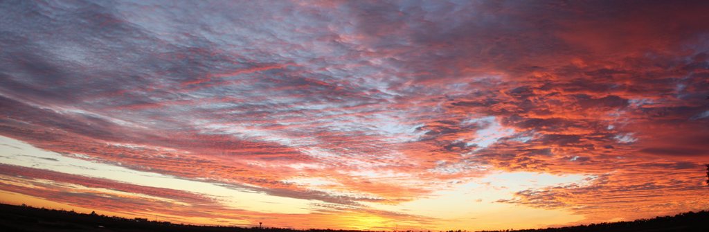
The clouds that were associated with the showers gave us an excellent sunset. Clouds make sunrise and sunset pictures interesting and I was out taking pictures when several other photographers joined me. We all agreed this one was spectacular. I put together a panoramic and will post it. We’ll see how the FMCA Web Site handles a panoramic photo. If you click on it you can get it enlarged.
Here is just a little fun for the map and geography fans in the audience... Port Hedland is near 20 degrees south latitude so we are still in the tropics. We are moving further west and are now at 119 degrees east longitude. That puts us 61 degrees west of the International Date Line. A little further west and we would be 180 degrees from New York City! That would be 105 degrees east longitude and we won’t go that far west but interesting to think about. We are still closer to the US if we travel east rather than west.
0 Comments
Recommended Comments
There are no comments to display.
Please sign in to comment
You will be able to leave a comment after signing in
Sign In Now