Roadtrekingmike
-
Content Count
669 -
Joined
-
Last visited
-
Days Won
17
Everything posted by Roadtrekingmike
-
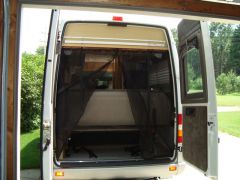
From the album: Cool Modifications to a Roadtrek: Screens and Cabinets
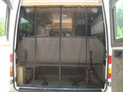
Rear door screens (Velcro) -
From the album: Cool Modifications to a Roadtrek: Screens and Cabinets
Rear screens -

From the album: Cool Modifications to a Roadtrek: Screens and Cabinets
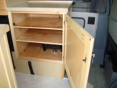
Driver’s side cabinet, open -

From the album: Cool Modifications to a Roadtrek: Screens and Cabinets
Passenger side cabinet, closed -
From the album: Cool Modifications to a Roadtrek: Screens and Cabinets
Driver’s side cabinet, open -

Cool Modifications to a Roadtrek: Screens and Cabinets
Roadtrekingmike posted a blog entry in Roadtreking Blog
We RVers love to share modifications we’ve done to our vehicles to make they fit our personal style. So it is with delight that a share a series of photos that show some very unique customizations done by blog reader Alan Shafer from Rockford, Mich., to his Roadtrek 2006 RS Adventurous. His photos are included. Here is his account: As you can see by the pics, it had four captain’s chairs. I removed the rear chairs and started from there. I have detailed pics of the whole process. The good thing is that I did not drill any new holes in the existing cabinets, etc. when doing the cabinets. I used all existing holes. The cabinets are made of 1×2 and 1×3 solid maple for the rails and stiles. The sides and doors are recessed panels made with maple veneer 1/4″ plywood. There was no stain used. They were finished with satin finish polyurathane. (Minwax) I was able to get a towel bar and electrical outlet on the side of the cabinet on the driver’s side. (Again, no new holes made in the existing cabinetry.) I also still have access to the storage area under where the seat on the driver’s side was located. The reason for not wanting to not make any new holes was that if we should decide to sell this Roadtrek down the line, I wanted to be able to put everything back to original in case the new buyer would want the van the original way it was. This can be accomplished in less that two hours. . . . maybe less. As for the screens, I made a frame for the screen which is mounted above the cabinet on the passenger side to cover that part of the door area. The rest is a magnetic closing screen (Magna Screen) that was purchased at Menards. The sides are held in place with self-adhesive and sew on velcro. The top is held in place by a dowel rod used as a curtain rod. To add some weight to the bottom of the panels, I did use lead weighted rope purchased at local fabric stores. (Field’s Fabrics) (Joann’s Fabrics) For the rear doors, I purchased two additional Magna Screens. This gave me four panels. I removed the magnets and sewed the panels together where the magnets were originally located. This gave me two panels. Then with self-adhesive and sew on velcro, I finished the project. I did loosen (or remove) some of the interior trim panels so the velcro along the sides would be hidden and also have the panels over the velcro to hold better. For all of the screens, I did have to sew a pocket at the top to go over the “curtain rods”. I also did have to shorten all of the panels and sew on a hem made from bias tape from the local fabric store. -
Howling for Wolves in Michigan’s Upper Peninsula
Roadtrekingmike posted a blog entry in Roadtreking Blog
One of the reasons so many RVers love Michigan’s Upper Peninsula is because of all the wildlife. And in recent years, the chance, albeit slim, of seeing a wolf has been at least a possibility that has made the place pretty exciting. For the introduction of the grey wolf into Michigan’s Upper Peninsula is one of the greatest wildlife management success stories in generations. Where there were none just a couple of decades ago, there are now around 700. On calm, clear nights, hearing the howls of a wolf pack is a thrill beyond description. And seeing them, as I did when three of them crossed in front of me while visiting Baraga County on a previous UP trip, is even more thrilling. They are truly magnificent animals. But the future is uncertain for Michigan’s wolves. Under a controversial policy that has sharply polarized many in the UP, the state’s Department of Natural Resources is moving ahead with a plan to allow the sport hunting of wolves in several areas across the UP, staring this fall. At the same time, citizen groups and wolf protection activists have countered with petition drives that would put the issue before Michigan voters this November, not once, but twice.. The issue is highly politicalized. A state representative from the far Western UP town of Ironwood claims that there are so many wolves making their way into town that local residents are afraid to send their children outdoors and are forced to stay inside because of the danger. While wolves, like deer, have been spotted in town, we found no evidence of widespread fear, or of rampaging wolves for that matter. There are lots of reports floating around about pets and farm animals being taken by wolves, too, though, on examination, I found many to be wild exaggerations or outright fabrications. In one of the more sensational stories, a local man who claimed to have had livestock killed by wolves was actually found by investigators to have allowed dead carcasses of animals who died of apparently natural causes to lie around his land. Such a practice would lead to odors which would naturally attract predators. That man had previously been given three donkeys by state officials. Since donkeys are known to keep wolves away, they would have protected his herds. But when officials went to check on the donkeys, they found the animals were neglected, with untrimmed hooves that prevented them from moving. Two of them subsequently died and a third was found “in very poor body condition,” said a state report obtained under a Freedom of Information Act request by wolf supporters. ”This animal is very weak and likely dehydrated since there is no water provided to the livestock,” said the report. Officials removed the surviving donkey, which is alive and “in a very good new home.” The report noted that the farmer had also been provided over $1,300 in fencing material to prevent wolves from entering his property. “The fence is now gone and its whereabouts are unknown,” concluded the report. I mention all this because this same farmer was all over the news earlier this year showing off dead cows he claimed were killed by wolves and talking about how dangerous they were. I visited with lots of folks who live in areas populated by wolf packs who reported no issues. “I believe if this hunt goes through we will once again see the wolf all but extinct in the UP,” said Sandy Lahtinen of Ironwood. “When hunters take out an animal here and there, they will take out the alpha males and females. That leaves the packs leaderless and creates lone wolves and that’s when you see problems.” Lahtinen has wolves on her property. She is not worried about them. Snow, her 30 year old pony, and a tiny little puppy roam about in her front yard all day. In Marquette County, Jim and Jackie Winkowski raise and race dog sled teams. They know wolves are in their area. They’ve seen and heard them. “They are not interested in our dogs,” said Jackie. “They are not interested in being around people at all.” In the deep and very buggy woods of the Ottawa National Forest near Ewen, we went out looking for wolf signs with Nancy Warren, the Great Lakes regional director for Wolfwatcher, a nonprofit organization dedicated to wolf conservation. You’ve heard of the Horse Whisperer. Nancy is the Wolf Howler. She talks to the wolves by howling in their territory. “Wolves are very territorial,” she says. “Howling is how a wolf checks to see if he is in another pack’s territory. The local wolves will howl back, to tell him to move on.” Although we spotted wolf scat, we didn’t get any answering howls that day. How do we know it was wolf poop, you ask? The size (an inch in diameter) and the presence of fur and bones in the fecal matter, explained Nancy. Aren’t you glad you asked that now? Warren is opposing the coming wolf hunt. “Wolves that cause problems already can be taken out by landowners if they endanger livestock or people,” she said. “A hunting season serves no purpose at all. There are only 658 wolves up here. To kill wolves for sport is just not right.” Nevertheless, the Michigan Natural Resources Commission on Thursday again approved hunting of once-federally protected wolves in the Upper Peninsula under a new state law passed to circumvent a referendum on an earlier hunting law, as called for by an earlier petition drive run by wolf supporters. State officials dismiss the concerns of the pro-wolf groups. “We anticipate that this limited public harvest could both change wolf behavior over time — making them more wary of people, residential areas and farms — and reduce the abundance of wolves in these management areas that have experienced chronic problems,” DNR Wildlife Division Chief Russ Mason said in a statement. “We’re aiming to decrease the number of conflicts and complaints while maintaining the long-term viability of the wolf population.” The group Keep Michigan Wolves Protected said it was “deeply disappointed” by the commission’s decision. The group earlier submitted petitions for a November 2014 referendum on the earlier wolf hunt law. That’s what promoted the Natural Resource Commission to push through the hunting season, before voters could decide. “The voters of Michigan — not politicians and bureaucrats — should have their voices heard on whether our state’s fragile wolf population is needlessly hunted for trophies,” group Director Jill Fritz said in a statement. “The NRC should have delayed a decision until the November 2014 election and let the democratic process play out as intended. Instead they have thumbed their noses at Michigan voters and told them their opinions don’t matter.” Fritz’s group submitted ballot said it plans to launch yet another petition drive to collect at least 225,000 signatures needed to place the new law under which the commission approved the hunt Thursday on the November 2014 ballot as well. That means there will be two anti-wolf hunting proposals on the ballot. But no matter how the issue is decided, it will be too late to stop this year’s hunt. And that should stir up howls of protests from all those who don’t think wolves should be considered fair game. -
Adding a Cell Phone Booster for my on-the-road RVing
Roadtrekingmike posted a blog entry in Roadtreking Blog
One of the challenges of being on the road so much and doing a blog like this is being reliably connected to the Internet in a whole bunch of different places. I’ve been a huge fan of the Verizon Mi-Fi card and the network’s strong nationwide footprint of 4G connectivity. It very reliably gives me near broadband speed as I travel. Sending video gobbles up a lot of bandwidth and almost all the videos I do for this blog were sent via the Verizon network. But lately, I’ve been going to some really remote locations. Last month at Yellowstone National Park, way back in the Lamar Valley boondocks, I saw a couple of wolf researchers from the University of Washington using their Verizon cellphone. The secret, they showed me, was an inexpensive cell phone booster that gave them several bars of connectivity when, without it, they had none. So with a trip to Michigan’s remote Upper Peninsula in the works right after my return from out west, I ordered one, too. There are lots of different cell signal boosters available but I picked up the same one the wolf researchers were using – the Wilson Sleek 4G, available online starting at around $75. It’s also stocked by many Walmart and Best Buy stores. It comes with a cell phone holder, cigarette plug power connector and a small magnetic antenna to attach to the roof of your vehicle. I hooked up mine on my Roadtrek eTrek, attaching the holder to the dash by an adhesive on the back. I attached the magnetic mount above the driver’s side roof and ran its connecting wire in through the side of the door. On my first trip to the wilderness at the Porcupine State Wilderness area in the far northern part of the UP, I put it to the test. You can see in the accompanying ideo that I had no connection at all. Not even a single bar. I was just too far from the nearest cell tower. So came the moment of truth. When I put my iPhone in the cradle, which contains the power booster, I now had coverage…. Three bars. Not bad. From zero to three bars. I could put the phone in the cradle or put the Mi-Fi card in and make my own hotspot. Over the past week, I have now traveled all over the UP and have been in some really desolate country. I have been surprised how many places had very good cell coverage without the booster. Verizon has really expanded its network. In the middle of the Ottawa National Forest, a vast expanse of one million acres, I actually had 4G coverage about 10 miles outside of the village of Watersmeet. But in several places just too distant from a tower, when my Mi-Fi or iPhone showed no or marginal coverage, the booster helped every time. -
On top of the Bighorn Range in Wyoming is Medicine Mountain, desolate and nearly 10,000 feet high and only reachable during the warm summer months. And on top of it lies a mysterious and ancient Native American medicine wheel that precisely predicts certain astronomical events. This is not a casual walk. It is 1 1/2 miles from the parking lot to the medicine wheel. And 1 1/2 miles back down to the parking lot again. That’s a three-mile roundtrip hike, at altitude. The wind blows continually and very strong up here, seemingly from every direction. There is little UV protection at such heights, so wear a hat and cover your skin. Carry water. The hike is climbs sharply. Even moderate exertion at such altitude can be stressful for your heart, so take frequent breaks. That’s easy to do because the scenery is breathtaking. There is nothing but wilderness to see in any direction. On the day we went, skies were bright blue, with big fluffy clouds. But mountain weather can change very fast and storms on Medicine Mountain can be fierce. Once you reach the top, you will find a small marker attesting to the mystery of the place and a walkway around the wheel, which is encircled by a fence. The Bighorn Medicine Wheel is an 80’ diameter wheel-like pattern made of stones. At the center of the circle is a doughnut-shaped pile of stones, a cairn, connected to the rim by 28 spoke-like lines of stones. Native Americans use this site regularly for religious purposes and special ceremonies called vision quests. Sometimes, Indians remain here for as long as four days, without food or water. The stone lines of this medicine wheel precisely point to where the Sun rises or sets on summer solstice and where certain important stars first rise at dawn after being behind the Sun. Some 80 different Indian Tribes hold ceremonies here and Indian prayer bags, pieces of cloth and other religious and ceremonial decorations are affixed to the rope fence. The wheel s part of a vast set of old Native American sites that document 7,000 years of their history in North America. The surface stones here are believed to be 700 years old. Beneath it are multiple layers of stones and rocks and because this site is sacred to Native Americans, no digging is allowed So no one is sure exactly how old this wheel is. Like Stonehenge, it has been built up by successive generations who added new features to the circle. Archaeologists suspect that the function and meaning of the medicine wheel changed over time, and it is doubtful that we will ever know what the original purpose was. There is no charge to visit the medicine wheel, though it sometimes closes to outsiders during Native American ceremonies. I can’t imaging a Class A making the climb, or finding a spot in the parking lot. It’s an easy ride for Class B RVs, and probably Class C motorhomes, too. The site is not easy to reach. The nearest town is Lovell, Wyoming, 33 miles to the east. The GPS coordinates ate Latitude: 44 degrees 49′ 32″ N.; longitude: 107 degrees 55′ 15″ W. During summer months, there are usually two National Park Service employees there, one at the parking lot, another on top. Besides preventing access during Native American ceremonies, they are delighted to answer questions. They also protect the site from artifact thieves. On top, visitors are asked to be quiet and respectful, as if in church.
-
I have a serious bone to pick with whoever calls Michigan’s Upper Peninsula a paradise. Not this trip. This RV adventure was a battle of the bugs. And while it looks pretty out the window of the motor coach, venture outside and you are fair game for swarms of insects that see you as smorgasbord. The mosquitoes and biting black and stable flies of the Lake Superior region are the worst they’ve been in years. Locals blame it on the unusually wet spring and summer we’ve had this year. http://youtu.be/g-UkHfr85mA Indeed, the night before this video was shot in early July, the area in the western Upper Peninsula around Gogebic County, where we were staying in the Porcupine Mountain State Wilderness Area, got drenched with three inches of rain. That said, I came prepared. I had bug spray, fly strips and a clip-on contraption that runs a miniature fan for 12 hours on three AAA batteries and is supposed to emit a personal cloud of protective repellant. Jennifer also brought along Avon Skin So Soft and even some vanilla extract, as suggested by blog readers. Then she stayed inside the Roadtrek all afternoon, relaxing and reading while Tai and I tested all the bug and fly fighting tools. They didn’t work. Nary a one. We only caught a paltry half dozen flies with the strip. Tai’s nose is all swollen from mosquito bites and he is giving me very dirty looks.
-
-
-
From the album: Beartooth Highway
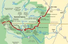
Beartooth Highway map -
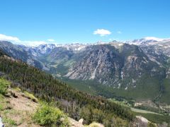
From the album: Beartooth Highway
West of the pass, the highway snakes downward into a relatively broad valley covered with lakes. -
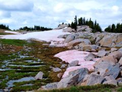
From the album: Beartooth Highway
Side of the road snow. The red color is an algae that grows directly on the snow surface as it melts. -
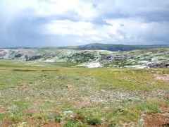
From the album: Beartooth Highway
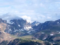
This is the glacial valley you climb out of to get onto the Beartooth Plateau. The road comes up the near side- this is taken at the rest area near the top. -
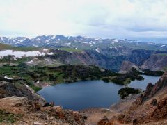
From the album: Beartooth Highway
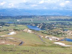
Mirror Lake – you have a front-row seat for viewing the valleys cut into the plateau. It’s straight down on the other side of the guardrail. -
From the album: Beartooth Highway
That dusting of white stuff isn’t snow, it’s hail. Much of the summer precipitation falls as hail at this altitude. Fortunately, it was all pea-sized up to a half inch or so. -
From the album: Beartooth Highway
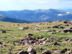
Fiona marmot-hunting at 10,948 feet -
From the album: Beartooth Highway
The Bear's tooth -
The Beartooth Highway is one of the more spectacular drives you can take when touring in your RV out West, comparable to the Going-to-the-Sun Road in Glacier National Park. It’s a 1930s WPA project that opened access to the Yellowstone region from the northeast, and an impressive engineering accomplishment. Fortunately for us, it’s still in good repair and easily traversable by all but the most anemic RVs – there are probably a few gas Class As that shouldn’t attempt it, but the rest of us can drive it easily. The eastern end of the Beartooth Highway is Red Lodge, MT, a 44 mile drive from I-90 coming down US 212 from Laurel, just west of Billings. Red Lodge is a nice little town with all the RV amenities – water and a dump station at the Chamber of Commerce, groceries at the IGA, gas, diesel and propane from multiple stations. Provision yourself well because the next significant amenities are when you come back out on I-90 in Livingston, MT, 175 miles away. OK, now that you’re all stocked up, get ready to climb. We’re going up onto the Beartooth Plateau, a 10,000-foot-high tableland overlooking the Yellowstone caldera. Trouble is, you’re at 5500 feet in Red Lodge. After a gently sloping approach up the valley, the switchbacks begin. Most of it is 25 or 30 miles an hour – feel free to take it slower. Turn off your air conditioner, and watch your coolant temperature and transmission temperature gauges. Five miles of switchbacks later, you’re rewarded with a view of the plateau. First thing you’ll notice is the snow. There’s snow up here – side-of-the-road snow, not up-on-the-mountains snow. I came up here in late June, and it’s all over the place. Even in August, there’s still snow you can easily walk to from the highway. The snowmelt feeds countless streams; most of the time you stop along the highway you can hear running water. The northern sides of the gentle hills on the plateau have snowbanks, each with a stream emerging from its base. The second thing you’ll notice is the thin, cold air. Atmospheric pressure is 70% of sea level, and it’s 20 degrees cooler up here in the summer than it is down in the Yellowstone River valley. Daytime highs are rarely above 70 degrees. Pace yourself if you plan any hikes, and watch out for signs of altitude sickness if you zoomed up here without acclimating. The first few miles of the plateau drive leading up to Beartooth Pass are still in Montana; I boondocked in a spur (Forest Service Road 2124) just before the state line, which is designated for dispersed camping. As you cross into Wyoming, you’re climbing – you’ll be rewarded with spectacular views of Gardner Lake and Mirror Lake. In addition to the main lakes, the complex landforms up here create smaller lakes seemingly cantilevered out of the steep slopes. Every dip in the terrain up here holds water. bearstooth The Bear’s Tooth is a spire of granite viewable from the highway just before the pass. Native Americans named this range because of this feature, which does indeed look like an incisor of something you wouldn’t want to meet on the trail. The tooth and many of the other peaks are “horns” – glacially carved spires sharpened to impossibly steep points as glaciers slid around their sides during the numerous ice ages which shaped this region. At the top, Beartooth Pass itself has a pullout to stretch your legs and look around in all directions. East you can see the Bighorns, over 80 miles away, and south of you is a plateau covered with lakes. Fiona the Fearless Kitty had less esthetic interests – she wanted to snag a marmot. Marmots are chubby rodents who inhabit alpine regions and, as Fiona was soon to discover, always sit within feet of their burrow. No marmot on the menu for Fiona this time. West of the pass, the road descends steadily and you come down off the tundra and back into pine forests. Spectacular waterfalls dot the roadside, many with pullouts and paths leading up to them so you can get a closer look. The state line also marks the boundary between the Custer National Forest and Shoshone National Forest, which you are in now, and there are several well-maintained campgrounds along this stretch of the highway. Island Lake, Beartooth Lake, Crazy Creek, and Fox Creek range in elevation from 9,000 to 6,000 feet. Information on these is available on the Shoshone National Forest website. Fox Creek has electricity, for those of you not equipped for dry camping. Somewhat averse to organized camping and neighbors ourselves, right now we’re doing dispersed camping maybe eight miles east of the town of Cooke City, on the Clark’s Fork of the Yellowstone River. Just pull off the road, pick a spot, and enjoy the wilderness. The sound of rushing water, the smell of the pine trees, and the song of the mountain bluebirds make this place a memorable stay in our exploration of the Beartooth area.
-
Yellowstone National Park is one of our most favorite places to RV in all of North America. It draws us back and its sheer size and beauty is breathtaking. We couldn’t resist sharing the wildflowers with you. I don’t know the names of them. But I do know they are stunningly beautiful. I think you’ll agree. As macro as the place is, it is also meant to be seen on the micro level, close up. So it was on our most recent trip, which just happened to correspond to the height of the spring wildflower season. Every color of the palette was visible, in forests, meadows and sagebrush-steppe. http://youtu.be/_-IFQxwJmpQ The place was literally ablaze with wildflowers. We saw dozens of different varieties and colors. The National Park Service tells us that Yellowstone is home to more than 1,350 species. There is white mule’s-ears and phlox, yellow arrowleaf balsamroot, blue penstemon and lupine, and Indian paintbrush’s glorious reds and oranges. Magenta shooting stars, purple sugarbowls, delicate white woodland stars and leopard lilies So we missed a lot, We photographed as many as we saw, as you can see in the video.
-
Yellowstone: At the top of every RV Bucket List
Roadtrekingmike posted a blog entry in Roadtreking Blog
Yellowstone National Park is America’s first national park, a national treasure and a must visit for every RVer. A place so big it lies in part of two states, Montana and Wyoming. We just finished our second trip to Yellowstone in less than a year. I was warned before the first that the place will get in your blood and you will keep coming back, again and again. http://youtu.be/e7iUKCJY95Q So if you haven’t been there yet, I pass along the same warning. It’s that spectacular for those who love the wilderness and getting up close and very personal with it. We did lots of hiking. There are 12 campgrounds in Yellowstone. They all fill up nightly. Only five - Bridge Bay, Canyon, Fishing Bridge RV Park, Grant Village, and Madison – take reservations. Those are the sites with hookups. They’re okay, but tend to be very crowded. The other seven - Indian Creek, Lewis Lake, Mammoth, Norris, Pebble Creek, Slough Creek, and Tower Fall – are first come, first serve and have fewer amenities. People tend to line up at 8 AM during the season in hopes of getting a spot. Most are filled by 11 a.m. Our first night there, we found no room at any of the campgrounds. So we went a few miles outside the northeaste gate and found a beautifully secluded spot at the Fox Creek Campground in the Shoshone National Forest. Then we reentered the park early in the morning and got a spot at Pebble Creek, which has no hookups or plugins, vault toilets and no showers. No problem. In our Roadtrek eTrek with solar power, we had our own power and running water. We love Pebble Creek. Also Slough Creek, another no frills camping spot few miles down the road. Here’s a hint for those of you on the northeastern part of the park: You can get cell phone coverage at Slough Creek. Take the two-and-a-half-mile washboard road leading to the campground down a few hundred yards to the first pullout and, voila, for some strange reason, the signals make their way around and through the mountains and you can get a great three-bar Verizon signal. I don’t know about AT&T and other providers. We love this northeast section of the park because it is home to the Lamar Valley, a popular wolf and grizzly watching area. We saw no wolves this trip but did spot several grizzly females with cubs, as well as elk,antelope, mule deer, coyotes, black bear and of course, lots of bison. We had bison wandering through the campground all day and a curious black bear came very close. A lone bull moose also traipsed through the campground one morning. The folks who camped at Pebble Creek were also interesting. One guy, Bill, spends from April through August and loves to find and watch grizzlies. Debi Dixon is a professional photographer and a fulltime RVer. She stores a 22-foot travel trailer in nearby Sheridan, MT and is spending the summer at Pebble Creek in a tent. Check out her stunning wildlife photos at flickr.com/photos/seasideshooter. There were two wolf researchers from the University of Washington also tenting at Pebble Creek. Every morning, at first light, usually around 5 or 5:30, you’d hear this group head out, separately, in search of wildlife. They’d usually not return after dark. What do we do at Yellowstone? We also watched animals. But we also hiked, a lot. Every day we did at least two trails. We sat in meadows and breathed clean air. We took afternoon naps. Gazed at the mountains and used a pair of binoculars to spot the big horn sheep. We explored the thermal areas that are everywhere, like at Old Faithful. The sad thing for most of Yellowstone’s visitors is people rarely get off the loop roads that circle the park. Some don’t even get out of their cars. With three million visitors a year, those roads can get pretty congested, especially with critter jams, the traffic tie-ups that frequently occur when animals are on the road or along its edges. But Yellowstone encompasses 2.2 million acres, and the loop road is just a tiny part of the park. Yellowstone is one of America’s premier wilderness areas. Most of the park is backcountry and managed as wilderness. Over 1,100 miles of trails are available for hiking. That’s where we like to be. We loved every moment of it and can’t wait to return. Yellowstone really does get in your blood. The above video gives you a idea. Come along with us .... -
On June 22, 2013 – at sunset local time from coast to coast, across the U.S., into Canada, as far north as Alaska – 19 different Roadtrek owners took a photo of their Roadtrek. Some were parked at campgrounds. Others in their driveway. Some drove to a special setting near their hometowns. I was at a rodeo in Cody, WY with mine. The point was to get a photo of our Roadtrek motorhomes at sunset, wherever we were. We’re thinking about doing this sort of thing a couple of times a year. Maybe for special occasions like the 4th of July (for Americans). What do you think? This little slide show shows what came of our first effort. Should we do this again? When? Shall we theme the photos?
-
-
-
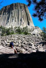
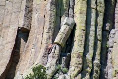
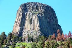
From the album: Devils Tower
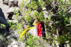
Native American prayer ribbons and bundles are on trees surrounding the tower