


tbutler
-
Content Count
2713 -
Joined
-
Last visited
-
Days Won
44
Everything posted by tbutler
-
From the album: Exploring Death Valley National Park
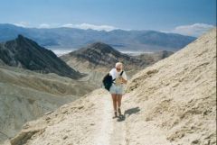
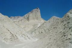
Manly Beacon is a prominent peak when viewed from Zabriske Point. It was named for William Manly, one of the guides that led the party of settlers into Death Valley by mistake. Manly left the settlers, found a way out of the valley then returned to bring them safely out of the valley they named Death Valley. No one from that group of settlers died in Death Valley. They survived by finding shelter under their wagons during the day. They ate their oxen for food and drank water they collected from the night dew. Two children were strapped to one remaining ox for the trip out. The adults walked out with shoes made of rags. The wagons and their supplies were abandoned when they left the valley. A very narrow escape. Louise is holding a hat because the wind was so strong. Shortly after this picture, she bent over to tie her shoe and her hat blew off. That was the last we saw of it. When it blew over the second line of hills I decided it wasn't worth retrieving.© © Tom Butler
-
From the album: Exploring Death Valley National Park
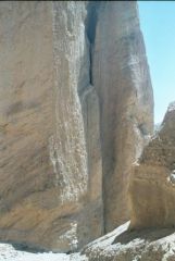
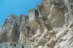
This is the entrance to the Red Cathedral, a box canyon with cliffs that tower above to a height of 80 feet or more and surround you on three sides. Look carefully at the base of the cliff and you can see Louise. It is a magnificent sight, well worth the hike.© © Tom Butler
-
From the album: Exploring Death Valley National Park
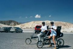
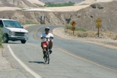
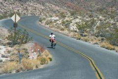
This picture was taken as we departed Zabriske Point for the trail head of the Golden Canyon Trail. The trial would bring us back to Zabriske Point where our car was and we would then drive back to the trail head to pick up the bicycles. Much better than hiking the trail in both directions. This way we could spend as much time as we wanted along the trail and knew that at the end we would have transportation. Most of the bike ride to the trail head was a downhill coast. Unfortunately, the wind was blowing in our face once we reached the valley floor and Louise had to walk her bicycle the last quarter mile because the wind was just too strong. Our Bike E bicycles were brand new on this trip. They provide us a very comfortable ride with full seats and a seat back. The Bike E company has gone out of business but there are still many kinds of recumbent bicycles being built. I recommend recumbent bicycles to everyone. The riding position is so comfortable, no craning of the neck to see the road ahead. When you get off the bicycle you stand up rather than teetering on your toes and trying to lift a leg over a high seat.© © Tom Butler
-
From the album: Exploring Death Valley National Park
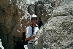
This is one of the narrow places along the trail to Red Cathedral. I could just barely squeeze through with the day pack on my back. In other places we had to climb up rocks on steep slopes and in one place had to work our way up a seven foot water fall face. We didn't have to use ropes but one would have been handy!© © Tom Butler
-
From the album: Exploring Death Valley National Park
Looking up at the sheer walls of the Red Cathedral formation.© © Tom Butler
-
From the album: Exploring Death Valley National Park
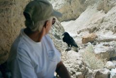
This raven hung around as we ate lunch in the shade of overhanging rocks on the Red Cathedral Trail. We never feed wild animals on the trail but they are welcome to any crumbs we may leave behind. As you can see, the raven got within a few feet of us but was not aggressive. This is how animals that have been fed in the past behave and with other animals it can be dangerous.© © Tom Butler
-
From the album: Exploring Death Valley National Park
This is the view of Manly Beacon seen from the trail as we are approaching. The trail skirts the vertical cliff on Manly Beacon. The view is great from up there but we had quite a climb ahead at this point.© © Tom Butler
-
From the album: Exploring Death Valley National Park
I started this ride at Dantes View, over 5000 feet above the floor of Death Valley. Louise followed me in the car so I didn't have to ride back up - thank goodness! The ride was 35 miles long and I was able to coast almost all the way to the Borax Works near the Furnace Creek Park Headquarters. There was some traffic but traffic is generally light and the speed limits keep traffic slower than on regular roads. Another ride I have taken which is similar to this is from the rim of Haleakala Crater on Maui in Hawaii. There an organized ride is an option you can pay to do. They provide the bicycles and snacks for the ride. That ride starts with champagne at sunrise on Haleakala and ends at the bicycle shop near sea level. I have also ridden from the parking lot at Mt. Lassen Summit Trail to our campsite near Mineral California. This was a distance of about 25 miles and required occasional light pedaling to complete the ride. Louise and I had hiked to the summit of Lassen Peak and when completed the hike, I took my bicycle off the car and rode home. Louise had dinner ready when I got home!© © Tom Butler
-
From the album: Exploring Death Valley National Park
This is the ride from Dantes View to the Borax Works near the Furnace Creek Park Headquarters. This was taken shortly after the beginning of the ride. I am descending the slope of the alluvial fan (deposts of sand, rock and gravel that form a skirt at the base of mountains from water erosion of the mountains). Alluvial fans have steep slopes. Just before this picture, Louise passed me and clocked me going 35 miles per hour - coasting! At times I had birds flying along side me at about the same speed.© © Tom Butler
-
From the album: Exploring Death Valley National Park
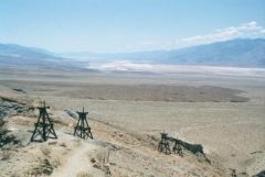
These are the towers that were part of the tramway at the Keane Wonder Gold Mine. The cable that carried the buckets of ore down the mountain were still in place in some of the towers. During its brief lifetime, the Keane Wonder Mine produced over 1 million dollars of gold and silver, no small amount of money in the early years of the 20th century. The mine was active from 1906 until 1912. The National Park Service has closed the area around the mine in recent years due to surface collapse and toxic wastes in the area.© © Tom Butler
-
From the album: Exploring Death Valley National Park
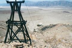
One of the Keane Wonder Mine tramway towers with the steel cables in place. Buckets of ore were carried from the main mine adit to the mill at the base of the mountain.© © Tom Butler
-
From the album: Exploring Death Valley National Park
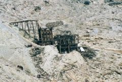
This is the origin of the Keane Wonder Mine tramway. Ore was brought out of the mine on a rail line and transferred to buckets which were carried down the mountainside on a tramway. The large wheel that drove the tramway is still present in the ruins. The National Park Service has recently closed this area due to safety concerns.© © Tom Butler
-
From the album: Exploring Death Valley National Park
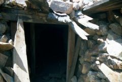
Do not enter here! This is one adit (entrance) of the Keane Wonder Mine. These mines were supported by timbers which are now about 100 years old. Couple that with the fact that the miners would take every bit of material out of the mine they possibly could because it contained gold and silver. Without sufficient support for the ceiling of the mine, it is slowly collapsing causing the surface to collapse as well. This is one of the reasons for closing this area.© © Tom Butler
-
From the album: Exploring Death Valley National Park
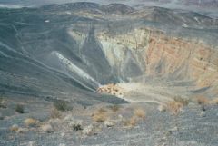
Ubehebe Crater is less than 10,000 years old, a relatively recent (in geologic terms) volcanic crater. We hiked all the way around the rim of this 500 foot deep, 1/2 mile diameter crater. Along the way we also had a nice overlook of Little Hebe Crater, a younger crater, which is just south of this crater. There is a trail to the floor of the crater but we didn't go there. It wasn't because it was unsafe, we were limited in time and decided to circle the crater rather than go into it. It was a windy cool day up on the rim of the crater at 2600 feet.© © Tom Butler
-
From the album: Exploring Death Valley National Park
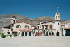
Scotty's Castle is a mansion built by a wealthy Chicago businessman. Walter Scott for whom the mansion is named, influenced Albert Johnson to build this villa as a vacation getaway for himself and his wife Bessie. Scott was a bit of a flim-flam man. He was known for selling shares in a gold mine that no one ever saw. Aparently the two got along well as they remained fast friends through the construction of this villa during the 1920's and 30's and Scott was quite at home in this estate. It has many guest rooms which were frequented by famous people including many actors and actresses of the 30's and 40's.© © Tom Butler
-

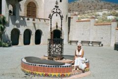
Louise Relaxes in the Courtyard at Scotty's Castle
tbutler posted a gallery image in Members Gallery
From the album: Exploring Death Valley National Park
Scotty's Castle was built by a wealthy Chicago business man. Scotty was known as a con man who sold shares in a gold mine no one ever saw. He latched onto a rich business man from Chicago and convinced him to build a beautiful retreat in the northern end of Death Valley. Scotty had a cabin nearby and managed the livestock and the estate. He made himself at home in the castle so his name became attached. Many movie stars and famous people came and visited here in the early 20th century. I had to laugh at the early 5KW generator in the equipment room. It was about the size of a tractor. We had a 7KW generator in the nose of our motor home at the time!© © Tom Butler
-
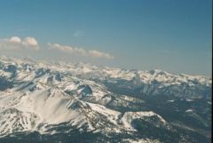
In Late Spring the Sierra Nevada Mountains Still Have Snow
tbutler posted a gallery image in Members Gallery
From the album: Exploring Death Valley National Park
On our flight back from Death Valley we flew over the snow covered Sierra Nevada Mountains.© © Tom Butler
-
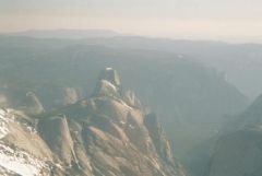
From the album: Exploring Death Valley National Park
On our way back from Death Valley we flew over Yosemite National Park. We were rewarded with this spectacular view.© © Tom Butler
-
Our Favorite Places - In Love With Deserts - Part 2
tbutler posted a blog entry in Tom and Louise on Tour in North America
Immediately after leaving Joshua Tree National Park we turned north to Death Valley. Our base of operations was just inside the Nevada state line at the Longstreet Casino in the Amargosa Valley. We arrived and parked at our very nice campsite, which was flooded in just an hour or so as the sprinklers came on at the golf course. We moved to a different site. It turned out that the Casino was celebrating their seventh anniversary and we would enjoy their celebration. They had scheduled David John and the Comstock Cowboys, a western singing group that we had seen several years earlier at a convention in Reno. We were there for each of their performances through the weekend. We even got the lowdown on the singing group from the parents of one of the band members who was sitting at the same table with us. We added to our collection of their albums and still enjoy the great campfire songs they sing. From the Amargosa Valley we traveled through Death Valley Junction into the park. Once we turned toward the park, we could coast most of the way to Furnace Creek and the park headquarters. On our first trip into the park we drove south from the headquarters to Badwater, which is near the lowest point in the park, more than 260 feet below sea level. Along the way we stopped to see the Artists Palette, the Natural Bridge and the Devils Golf Course. The following day we contrived a bicycle ride from Zabriske Point, coasting down to Badwater Road to Golden Canyon. It turned out the wind blowing through the valley was strong enough that Louise had to walk her bike the last quarter mile. We locked up the bicycles at the Golden Canyon parking lot and then hiked back to Zariske Point, where we had left the car. On the hike we took a side trail to see the Cathedral formation and had lunch on the way back from that side trip. Sitting in the shelter of an overhanging rock in the narrow stream, we were joined by a Raven that waited just a few feet away from us as we ate. We continued on over Manly Beacon and then to Zabriske Point. We lost a hat along the way when Louise bent over to tie a shoe. I started to go after it, but after we watched it cross the second line of hills, I decided it wasn't worth it. Death Valley is a desert virtually without plants. It is just bare naked rocks! As a retired earth science teacher, I found the exposed rocks and the erosional features laid bare to be quite amazing and in their own way beautiful. It is obvious that there are periodic heavy rains within the park as the evidence of water erosion is everywhere. In fact I remarked to Louise that I would rename the park, "Erosion National Park." Once we arrived at Zabriske Point we retrieved the bicycles and returned to camp. The next day we drove to Dantes View, which overlooks Badwater from 5,600 feet above and just two miles from the lowest point in Death Valley. The view was spectacular and I formulated the plan for the next bike ride. The next day, Louise drove me to Dante's view. I unloaded my Bike-E and coasted from there to Furnace Creek, a distance of 23 miles. I had to pedal just a few times, but most of the time I was just enjoying the ride. Coming off the alluvial fan at Dante's View, Louise clocked me at 35 miles per hour -- coasting! What a ride! We moved to the Stovepipe Wells Campground after several weeks. This was the only campground in the park with hookups and it only had 30-amps and water. We stayed for just four days as the temperature was now hitting 100 degrees every day. From Stovepipe Wells we explored the northern end of Death Valley, including Scotty's Castle, the area around Ubehebe Crater and Emigrant Canyon. We also saw the Desert Pupfish in Salt Creek. Our favorite adventure in this part of Death Valley was a hike to the Keane Wonder Mine. The trail to this abandoned gold mine features the remains of a tramway used to bring the ore down the mountainside, several entrances to the mine and the main shaft opening and processing center at the top of the tramway. The trail is a torturous 1,300-foot climb in about a mile of trail. We had lunch at the mine site and enjoyed a spectacular view across the valley before descending. At the base of the mountain is the mill, which we explored after the hike. Our egress from Death Valley provided another thrill. Departing from Stovepipe Wells to the west on California Highway 190 provides some heart stopping driving for RVs as the road is narrow with no shoulder and steep drops. Louise had a spectacular view out the passenger window when she could open her eyes. I bought a paperback book, Death Valley '49, written by William L. Manly, one of the guides who led a pioneer group into Death Valley. After finding a way out, Manly returned to save the pioneers who had been left in Death Valley. No one died in Death Valley, but the wagons were abandoned and most of the oxen eaten while in the valley and on the way out. The tale was a riveting description of the hardships endured by these '49ers as they traveled west to a better life. Our final encounter with Death Valley on this trip originated from Visalia, CA. I got checked out in a Piper Arrow at the Visalia airport. From there we flew over the Sierra Nevada to Death Valley making a landing in the park at the Furnace Creek airport. This airport is the lowest airport in the US being almost 200 feet below sea level. We had lunch and then took off for the return flight. We circled over the Keane Wonder mine and flew east to the Amargosa Valley and our campsite at the Longstreet Casino. Then we crossed Death Valley again headed westward over Scotty's Castle and Ubehebe Crater. Continuing on east, we crossed over Yosemite National Park, we saw frozen lakes and Half Dome from the air. We landed in Columbia, CA had dinner and then flew back south through the central valley of California at night. -
Verizon Wireless Key
tbutler replied to berginaperzina's topic in RV Internet to Go/Staying in Touch
I just switched to Verizon wireless phone and spent the next two weeks at a campground with no service. I couldn't get service at my daughter's home, either. In a final insult, when I could get service there I couldn't pick up my voice mail. This was in California, not Alaska! So, yes, it does depend on where you travel. We've been using AT&T for Louise's cell phone, Sprint for mine and T-Mobile for Internet with the theory that we should surely have one of the three working so we could communicate with family. T-Mobile works well for us for cellular, their service isn't the fastest but we find few places were we can't get service. Sprint was not very good for cell service, the vote is still out on Verizon... -
I'm with Wayne, got to have the latest greatest! I have no idea how my step works! When I open the door it comes out. If I start the engine it comes in. If something goes wrong, there is a light on the dash that indicates "Step Out". Magic is wonderful. If I turn on the step switch, it comes out every time I open the door and comes in every time I close the door. So I don't worry about the switch. Open the door and the step goes out and stays out. Start the engine and the step comes in. It works for me! Now if I could ever get this pants and shoes thing down, I'd really be on top of the world!
-
Talk to Allison about your concerns and see what they say. Anything that is programmed can be reprogrammed. I have had our Allison transmission reprogrammed to adjust for my driving style when we purchased a used motor home. Actually it was deprogrammed and then set to learn mode again. I'm sure they can make an adjustment for tire diameter if need be.
-
For my money, nothing beats and FMCA Convention! If it is motor homes you want to see, you won't be distracted by dozens of trailers, etc. Check the convention schedule for the coming year. You can attend even if you don't own a motor home. By the way, you meet thousands of motor home enthusiasts who are more than a little willing to talk about their motor home! All this and there are workshops on a wide variety of topics and entertainment. By the way, Neal and Carol, we used to live in the St. Louis area before we bought our motor home!
-
Green Beaver is on target! We have used the RM Motor Carrier's Atlases for years. The detail is great and the large-scale version is perfect for those of us who find tiny type difficult to read while bumping down the road. They are laminated and will last longer than you want to keep them. We still go back to the large scale version that is several years old for detail we can't get in the regular version. This all being said, today I put the computer with MS Streets and Trips in front of my technophobe wife and I think she will likely not use the maps again. She said something to me yesterday about not having the detailed view of some small town in western Nevada and I thought, "I'll bet the GPS maps would answer that question." So I set everything up for her today. We were in new country, on a route we'd never taken before. She was into the maps on the computer in no time. I could tell she was enjoying the whole "new" process when she started offering me several different routes to save time/distance. She noted all the small side roads that were showing up on the computer. At one point she started reading off all the information on the screen to me and I knew my life would never be the same! Now we have two GPS units, his and hers. It is still good to grab the map for an overview sometimes but nothing beats the detail you can get from GPS maps. Only time will tell if we ever rely on the paper maps like we have in the past! Now, this is the FMCA web site, so I must confess that this summer while traveling with Pipewrenchgrip and Laura they were able to locate Wal-Marts better than our GPS using the FMCA Atlas.
-
We've had a number of these kinds of queries and if your dealer or E-Bay doesn't help, check the RV salvage shops. There are several entries among these posts (use the search feature) that give references for RV salvage. Some of these salvage yards specialize in manuals and documentation. They do ship across the country so you wouldn't have to be near one to get satisfactory results.